There were seventy-two jobs on my ‘to do’ list that I wanted to complete before departure day; of the seventy-two, I managed to complete all but two, which wasn’t too bad. The two I didn’t get done were picking up some fallen timber and the installation of a skylight in the kitchen, but I suppose they will wait until we get back in twelve months’ time.

One of the 72 jobs
Up early this morning and packed technological necessities such as my laptop, Bev’s iPad, digital cameras, mobile phone, leads for downloading, chargers and a heap of other gadgets. It never ceases to amaze me just how much muck we need these days to go travelling, but that’s how it is if you want to communicate with the world and keep a check on what is happening at home. I started packing the car about three weeks ago and when you consider we needed to pack for the heat and humidity of the northern Australian tropics and the minus temperatures of the Swiss Alps and Sweden there is simply a lot of ‘stuff’ to stuff in. In addition we have our two double sea kayaks in tow, which adds to the load.

Toby Kate Isabella and Hamish
Looking after things at home
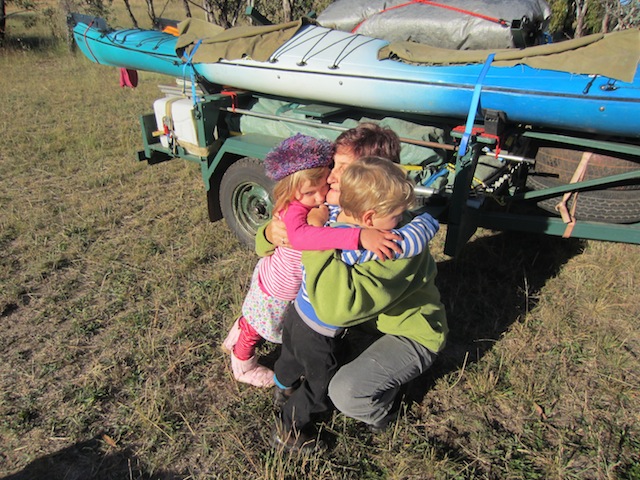
Hugs for Grandma Bev
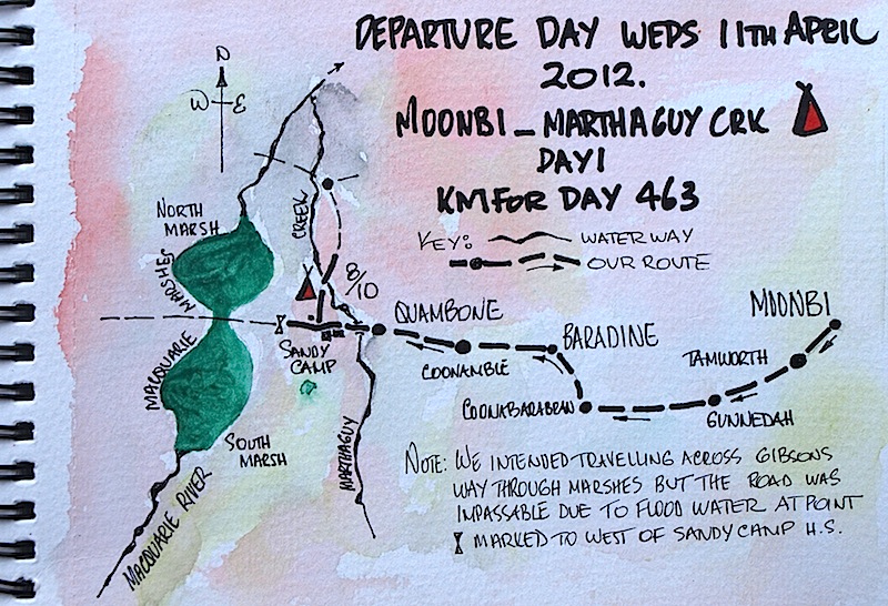
After the goodbyes we headed west to Baradine in the heart of the Pilliga Forests then to Coonamble and on to Quambone from where we intended to follow Gibson’s Way, a narrow track separating the south and north Macquarie Marshes. Whenever we travel out west we always find an excuse to go via the marshes as I have had a long association with them starting in the early 1960s when I was working for the Water Conservation & Irrigation Commission (WC & IC) based in Dubbo. In 1965, the year of the big drought, I surveyed the marshes when they were dry and with Ian, my friend of over forty years, I spent many weekends kayaking through and camping in them.

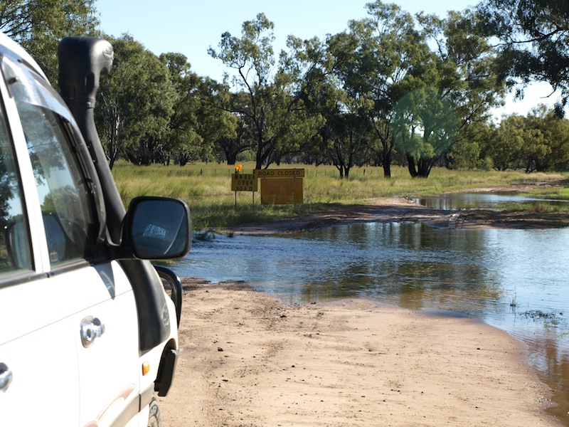
Water across Gibsons Way
Today, unfortunately, the traverse of the marshes was not possible as soon after leaving Sandy Camp (a large pastoral holding on the edge of the marshes) we came to the dreaded sign ‘ROAD CLOSED’. A closed road sometimes means a hundred or more kilometres detour; in the case of Gibson’s Way it meant backtracking about ten kilometres, which wasn’t too bad, but just the same I wonder why the authorities didn’t erect the sign well before the actual closure site. It should be noted that in some states if you travel a closed road there are severe penalties and if you get caught the fine could be up to a $1000 per wheel.

Northern marshes in good times
Before the days of GPS navigation it was easy to get lost when kayaking in the marshes. The only way to know where we were was to climb a dead tree and take a sighting. Sometimes we had to camp in the reed beds because we couldn’t get to dry land and this presented certain dangers from wild pigs and snakes that wanted to share the spot with us. When we arrived at a campsite snakes usually disappeared down cracks in the ground so we stuffed a piece of dry cow dung into the crack and sealed them in until morning. Today most of the marshes are classified as Nature Reserve, meaning the only humans allowed in are researchers and National Park officials. One day I will sweet talk someone and get back into the marshes, just for old time’s sake.

The Macquarie Marshes in drought
The car tracks, shown in the photograph above, follow one of the channels through the marshes. It is easy to imagine how scenic and exciting the paddling would be if there was a metre of water, a green reed bed, a few wild pigs and a thousand water birds.
The first European into the Macquarie Marsh area was explorer John Oxley in 1818. Oxley set out from Bathurst to trace the route of the Macquarie River. He believed, as a lot of people did at the time, that the west flowing rivers discharged into an inland sea. Oxley was so confident that he was going to discover the elusive inland sea that he included a whaleboat in his expedition paraphernalia. When he reached the vast reed bed we now know as the Macquarie Marshes he proclaimed he had found the sea, abandoned the whaleboat and turned east to emerge on the east coast in the region of what is now Port Macquarie.
The first pastoralist into the area was George Gibson who built a bark hut on the west side of the marshes and the cattle he raised were sent to meat-hungry gold miners around Mudgee. More settlers arrived and eventually the region was all taken up. In more modern times the marshes were subdivided into blocks and the blocks were leased to local landholders who used the lush naturally irrigated pastures for fattening cattle. It was during this time (1960/70s) that we did most of our canoeing in the marshes. Eventually the lease blocks were turned into a nature reserve, which meant no more kayaking or camping.
These days the marshes are starved of water more often than not because diversion channels have been built around them to redirect water to cotton growers downstream. Over the past forty years I have seen the marshes change from a pristine wetland to a mostly dry degraded wasteland. This year, however, because of flood rains in the catchment, the marshes are like what they used to be.
When the marshes fill, thousands of water birds arrive, some from as far as the east coast of NSW and this begs the question, ‘How do the birds know water is flowing into the marshes and how is it possible they can coincide their arrival with the arrival of the water?’

The marshes on Day 1 of our journey
This is how I like to see the Macquarie Marshes, water fence-post deep. When kayaking through the marshes, fences like this one were a problem, especially if there was a strong current. It is extremely difficult to get a kayak over a fence such as this; a pair of fencing pliers usually overcame the problem. Of course we always reattached the wires! Fences partially submerged were not only a hazard for us but for large birds such as pelicans and swans. As they landed or took off they crashed into the almost invisible wires. Now the marshes are under the control of the National Parks the bulk of the fences have been removed. On one trip we had a friend from Sydney come along and as he was going under the top barbed wire he caught his hair on a barb; no harm done though as unbeknown to us he had a toupee on and there it was, dangling on the fence!
Kayaking through the marshes in the 1960s was a real adventure. Leaseholders of marsh blocks encouraged us to shoot any wild pigs we came across. On the front of our kayaks we had a rifle scabbard and as we drifted we took pot shots. Wild pigs are a disaster in wetlands as they destroy bird nests and eat fledglings and eggs. Some water birds such as ibis are smart though, they build their nests in flimsy clumps of Lignum bushes which are impossible for predators to climb. On one occasion we found ourselves in the middle of a Lignum bush ibis rookery and the birds, thinking us a threat, picked up sticks and flew over us dropping them in an attempt to see us off.
Mosquitoes were bad and so were leeches, especially the ones we called horse leeches. They would swim alongside our kayak and when we stopped they came aboard. (One night on a bushwalk in Tasmania I dreamt that I was chewing liquorice but on waking it turned out to be a leech and after spitting it out I wondered what would have happened if I had swallowed it!)
Backtracking from the closed road sign we returned to Sandy Camp and turned north, following the back Carinda road until we hit the Marthaguy Creek where we are now camped. It’s a pleasant camp with plenty of firewood and no passing traffic.
It has been an enjoyable day even though we couldn’t drive across Gibson’s Way. We are happy to be on the road after all the planning and the seventy jobs under my belt.
We travel the world to find the beautiful, once we find it we must carry it with us or we find it not.
