PART 1 of FRED and BEV’S TORRES STRAIT ENCOUNTER.
The Torres Strait Encounter follows on from our Encountering the Past Odyssey
In light of the effort involved with writing our last travel Odyssey blog I have decided not to go down the same path and report on every day’s activity but write about the demography, geography and our experiences and adventures in Torres Strait in more general terms. I hope you enjoy the postings and the change of theme.
The first thing I have to do is get you orientated and the only way to do that is with a map.

Torres Strait. Note how close the Queensland border goes to Papua New Guinea.
Torres Strait comprises an area of approximately 35 000 square kilometres (approximately half the size of Tasmania), of which 2.6% is terrestrial land, 6.2% tidally inundated reef flats, and 91.2% open seas, most of which are relatively shallow. The Strait stretches from Cape York, the most northern tip of mainland Australia, to within thirty kilometres of the Papua New Guinea mainland. It is administered by the Commonwealth, Queensland and local governments as well as the Papuan New Guinea government.
Geographically the islands of Torres Strait can be divided into four (some references say five) main groups. Eastern—high volcanic islands; Central—comprising low sandy islands; Western—high islands composed of volcanic and granitic rocks; and Northern—low islands composed of mangrove muds and peats.

Map showing the Inner Western group of islands.
Wednesday and Tuesday Islands were named by Captain William Bligh in 1789. Note the proximity of Cape York and Endeavour Strait. The only permanent residents of Friday Island are Japanese Kazuyoshi Takami and Mariko Tatsuzawa, who run Friday Island Pearls.
Bev and I arrived on Thursday Island in April and since then we have come to understand a little about the vast Torres Strait region. Since we have been here we have managed to explore not only Thursday Island but a few of the outer 150 islands, islets, coral reefs and cays as well.
First contact visitors have when coming to Torres Strait if not by sea, will be when their flight from Cairns lands on Horn Island. There is no airstrip on Thursday Island as there is no flat land available. To get from Horn to Thursday Island people take a twenty-minute ferry ride. There are two companies running ferries but we take the Australia Fair as it is a nostalgic trip for me. This small ferry once carried people around Sydney Harbour and having lived in Sydney as a child I travelled on similar ferries on many occasions.
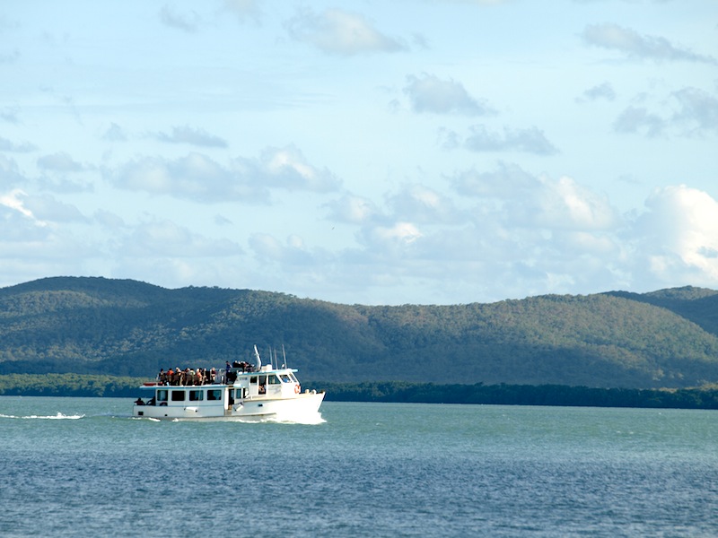
The ex Sydney Harbour ferry ‘Australia Fair’ passing by Prince of Wales Island en route from Horn Island to Thursday Island.
Horn Island is the transport hub of Torres Strait as it has the airport. Not only do large aircraft come and go on a daily basis but small aircraft are constantly going to far-flung islands as well. Barges take supplies from Horn and Thursday Island to the outer islands and from what I understand, island life revolves around when next the barge comes in.

Stern view of the inter island barge Mau Chief. Barges like this are the lifeblood of the islands.

Plying the channel between Prince of Wales and Thursday Island..
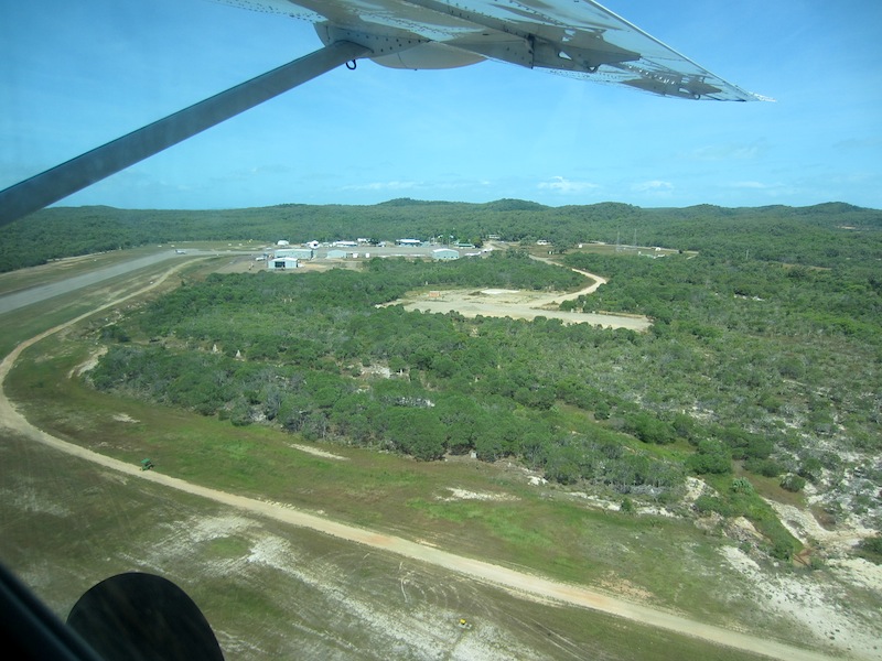
Horn Island airport.

One of the many inter-island aircraft used to connect Horn Island with the islands of Torres Strait. This pilot is delivering the ‘ditching in the sea’ procedure.
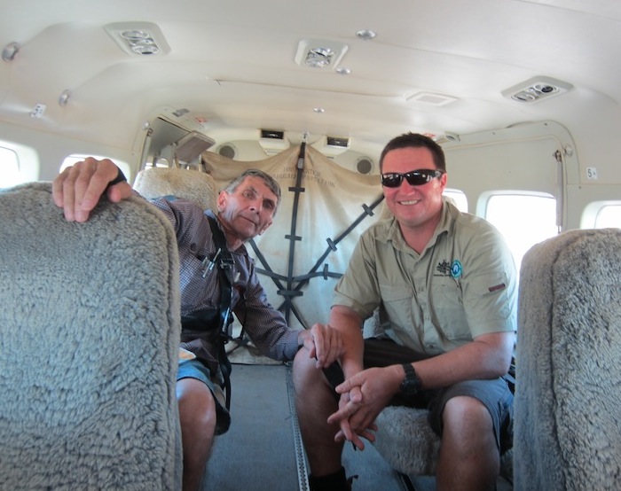
Tim and I in a twin-engine aircraft on our way to work on an outer island. On this trip Tim established a community garden and greenhouse and I did pottery with island children.
Not all people in the Torres Strait fly, some have aerophobia or simply cannot afford to fly. These people have no alternative but to take to the seas in small runabouts. Getting around the Torres Strait islands in small boats is rather unique and it involves a lifestyle that mainlanders find rather amusing. Early morning activity at the Thursday Island boat ramp sees small boats bringing school children, workers, shoppers and those with business to attend to from neighbouring islands.
The two most popular brands of boats used for inter-island travel are Wahu and Hooker.

A Wahu (foreground) and a Hooker.
Both the Wahu and the Hooker are relatively long in relation to beam width. They are made from fiberglass and are fitted with up to 100hp outboard motors. Both are ‘tough numbers’ and ideally suited to the sometimes very rough conditions. Young landlubbers on the mainland dream of buying their first car, young Torres Strait Islanders dream of buying their first Wahu or Hooker.
As would be expected, many islanders come to grief when travelling between islands and there are many reasons including motor malfunction, not carrying sufficient fuel for the journey or they are overcome by unexpected weather changes.
The Australian Maritime Safety Authority (AMSA), who are responsible for enlightening the locals as to water safety and for search and rescue operations, have made great inroads into raising people’s awareness as to what to carry on their boats when venturing onto the high seas. AMSA recommend, among other things, that an anchor, spare fuel, water, food, Vee sheet, VHF radio, paddles, flares and an EPIRB be carried. An EPIRB (Emergency Position Indicating Beacon, pronounced ee-pirb), is a device that transmits a digital signal on the international distress signal frequency 406 MHz. Designed to work with satellites, EPIRBs are detectable by COSPAS-SARSAT satellites which orbit the poles. Once an EPIRB is set off the authorities spring into action to effect a rescue. Fortunately almost 100% of EPIRB activations have fruitful outcomes.

Map showing EPIRB and operational incidents for Queensland for the 12 months period March 2010 to March 2011. Map courtesy of AMSA.
The total number of EPIRB incidents (red dots) for the above mentioned period was 439. It is interesting to note the density of the events in the Torres Strait.
Not all EPIRB activations are locals. Recently Daniel Alary, a French solo round-the-world sailor sailing through Torres Strait rough seas in his 2.7m micro yacht Poisson d’Avril (French term for April Fool), activated his EPIRB following aheartarrhythmia occurrence. There are a number of causes relating to heart arrhythmia and they include stress, too much caffeine or nicotine, or too much exercise. Our lone sailor may not have been having too much caffeine or nicotine but he was under stress and he was probably getting far too much exercise because the sea was running at 3m high waves and the 40 knot winds would have been knocking him about in his little bathtub.
The skipper, aged seventy, was on the first leg from French Polynesia to Darwin on his round-the-world adventure. He was rescued under very dangerous and difficult conditions by a Thursday Island based rescue helicopter and was treated at the Thursday Island hospital. His yacht is yet to be salvaged.
When I heard that the rescued sailor was in the T.I. hospital I thought I would visit him and give him one of my bathtub paintings but alas he had been discharged and was on his way (flying) to Darwin!
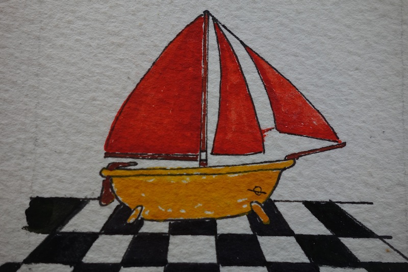
A Tubber.
There is a club that races bathtub boats and most of the ‘tubs’ are made from fibreglass and are modelled on a bathtub.
Before Wahus, Hookers, EPIRBs and other modern boating paraphernalia the locals simply paddled and sailed their canoes. Some had outriggers and sails and could carry a dozen people.
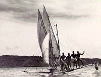
Large Torres Strait canoe under sail. Image courtesy of Australian War memorial.

Smaller dugout of a past era. I do appreciate the work involved with the making of such craft, especially in light of no power tools or chainsaws being available at the time.
The largest island in the Torres Strait is Prince of Wales (around 205 square kilometres). It has a population of approximately twenty five. The Prince of Wales is one of the few islands in Torres Strait where an outsider can buy land and live. The first weekend after our arrival we visited the island to take a swim in a freshwater pool and at the time I thought persons buying land and setting up home on the island would really want to be getting away from it all.
On Prince of Wales Island there are fresh mountain streams, wild pigs, goats and deer. During sailing ship days many such animals were let loose in the hope that shipwrecked sailors who made it ashore had a chance of survival.

An island rock pool.

Tim coming ashore on Prince of Wales Island.
Thursday Island, also known as T. I. or Waiben, is located 39 kilometres north of Cape York Peninsula and 800 metres from Prince of Wales Island (P o W in local jargon). T. I. has a population of around 3500, and is about 3.5 square kilometres in area; the highest point stands at 104 metres (341 ft) above sea level. It is possible to buy a building block on TI for around $150 000 upwards.

Thursday Island. Photo TSRA (Torres Strait Regional Authority)
One of the main reasons Thursday Island was chosen as a settlement was because of its ideal location for the reef pilot operation. There were a number of factors that necessitated the introduction of a pilot service and among them were jagged rocks lurking just below the sea surface, hundreds of coral reefs and tides running at up to eight knots (15 kph) back and forth through the narrow waterways.
The settlement on T I was not the first in the region; the first settlement was at Somerset about 50 kilometres down the coast from the tip of Cape York Peninsula. However, Somerset was not close enough to the geographical centre of the strait and in 1876 after much discussion it was decided that Thursday Island would be the most suitable for development. Once the decision was made to develop T. I. business began to flourish. Most of the businesses revolved around the exploitation of the region’s natural resources and passing shipping.
The pearl diving industry was big business in and around Torres Strait with all nationalities involved, particularly the Japanese. There are hundreds of Japanese tombstones and a large monument in the T. I. cemetery bearing witness to the fact.
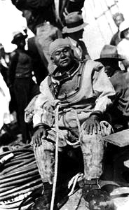
Japanese pearl diver T I.

Japanese memorial monument.
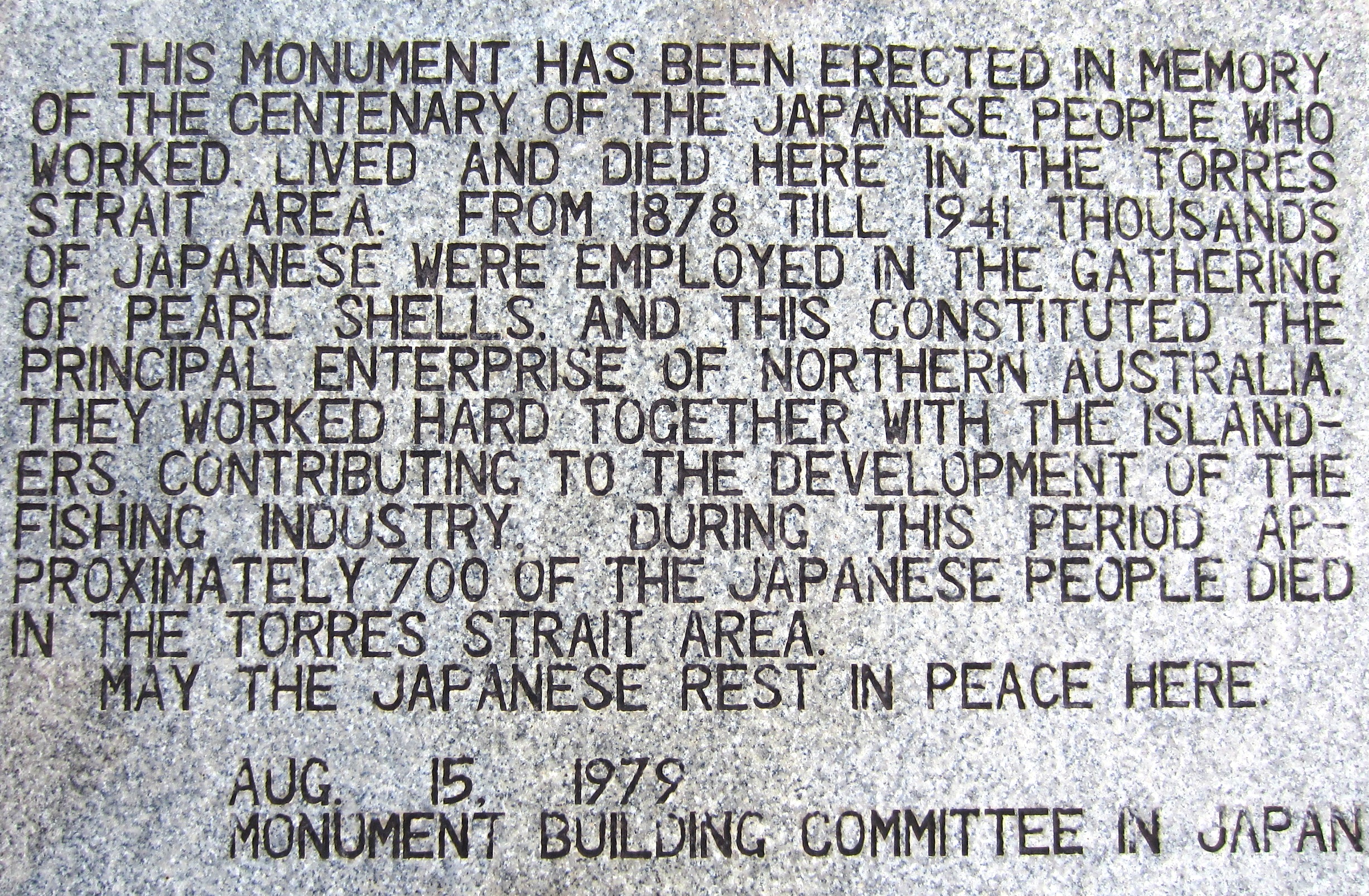
Memorial plaque on the Japanese memorial monument.

One of the hundreds of Japanese tombstones in Thursday Island cemetery.
There is a rumour that a Japanese princess is buried in the cemetery and that is why Thursday Island was not bombed during WW2.
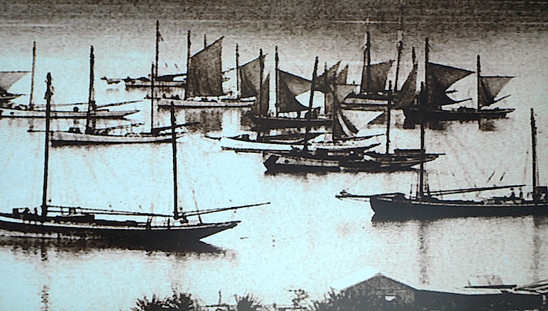
A few of the many luggers that anchored off Thursday Island in the late 1800s.
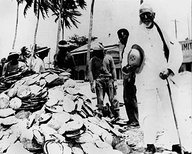
A stockpile of pearl shell, one of the sought-after resources.
Pearl shell was used for making buttons and pearl shell and abalone dust was, and still is today, added to automotive paints to give the finished paint job a metallic appearance. The outer layer of pearls and the inside layer of pearl oyster shells are made of nacre. Nacre is an organic-inorganic composite material produced by some molluscs.
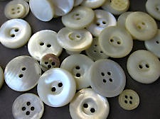
Mother-of-pearl buttons.
Victoria Parade Thursday Island in early settlement days.

Victoria Parade today.

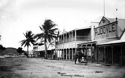
Shops in the main street, Thursday Island.
A main street shopfront, Thursday Island.
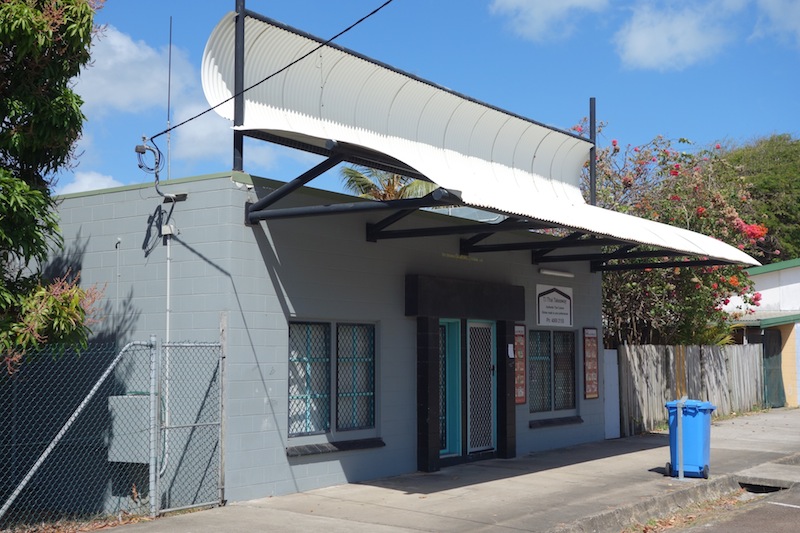
I have included the above photograph because of the unique curved corrugated iron parapet. The curved iron turns a boring concrete block building into a classic piece of architecture. Architecturally-minded blog readers would no doubt agree. Brilliant!
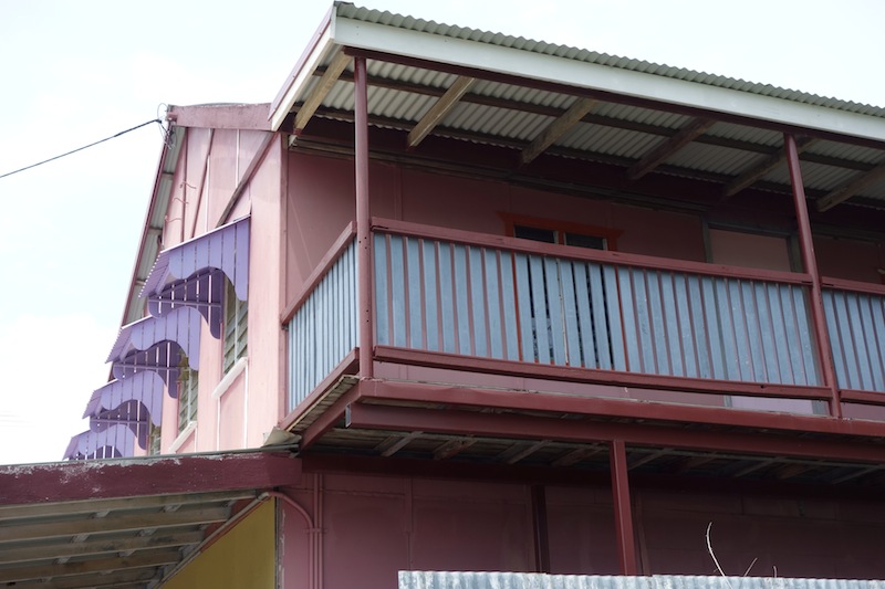
One of the many classic old buildings in the main street of T I.

Corrugated iron, the great ornament of the Australian landscape.

Thursday Island Post Office.
The Thursday Island post office shown above was not the first in Torres Strait. The first was established on Booby Island 33 kilometres west of Thursday Island in the early 1800s and its establishment came about in a curious way.
Captain Hobson of the ‘Rattlesnake’ was unwittingly responsible for the establishment of a post office on Booby Island. He suggested that a logbook be placed in a cave on the island where captains of passing ships could make entries relating to their movements. Because the cave became a focal point, ship captains began using the location as a place to drop or collect mail and as a result the cave became the first post office in Australia.
The original 1853 and replacement logbook disappeared some time during the 1880s, a sad loss when one considers the great wealth of irreplaceable historical information contained in those books. Maybe they will turn up in a dusty attic or in a shoebox under a bed one day.
The cave on Booby Island was not only used as a post office and refuge but provisions were placed in the cave as well, allowing shipwrecked sailors to survive while waiting for a passage out of Torres Strait. At the time the Legislative Council of New South Wales (NSW occupied the whole east coast of Australia at the time) voted the sum of fifty pounds to cover the cost of provisions to be left at Booby Island for the use of shipwrecked people. It seemed that the practice of provisioning Booby Island continued until the latter part of the nineteenth century. Passers-by also left food such as rum and other useful items. Booby became known as ‘Port of Refuge’ because of the cache.
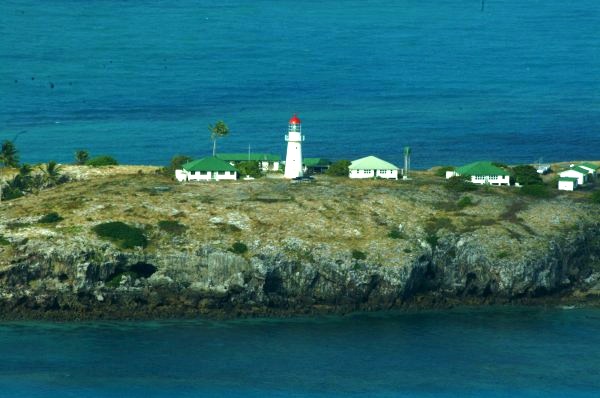
Booby Island Lighthouse. Photo by Peter Braid. Lighthouses of Australia web page http://www.lighthouse.net.au
It is not known when the cave on Booby Island was last provisioned. By the late 19th century the population of the region had negated its necessity. In 1877 there were over seven hundred people of varying nationalities working in the Strait harvesting its natural resources.
The next posting tells the story of how the Torres Strait islands were settled.
