PART 3 of FRED and BEV’S TORRES STRAIT ENCOUNTER.
Early explorers and Torres Strait Discovery.
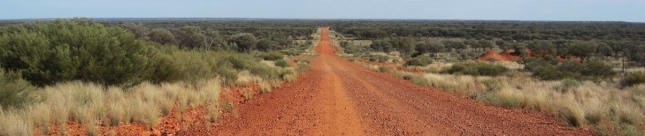
In 1598 Dutch historian and cartographer Cornelius Wytfliet said, ‘The Terra Australis is the most southern of all lands and is separated from New Guinea by a narrow strait…. it is ascertained by some to be of so greater extent that if it were thoroughly explored it would be regarded as a fifth part of the world’. Wytfliet was right, for the narrow strait he referred to is what we now know as Torres Strait, part of Australia. Although not referred to as the fifth part of the world these days, Australia is big. It is the sixth largest country after Russia, Canada, China, the USA and Brazil.
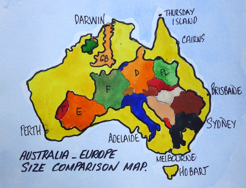
Map showing size comparison of Europe to Australia.
THE FIRST NON-MELANESIANS TO PASS THROUGH TORRES STRAIT.
LIBYANS 239BC: It’s difficult to determine who may have been the first explorers to pass through Torres Strait. There is one report following the discovery of hieroglyphics in West Irian caves that the Libyans in longboats may have passed through Torres Strait region or may have even sighted the Australian mainland as far back as 239BC. As to be expected, no documentary evidence exists relating to the Libyan adventurers so the theory has to be treated with caution.
MENDONCA THEORY and the DISCOVERY of AUSTRALIA.
CAPTAIN CRISTOVAO MENDONCA 1521: Mendonca’s involvement in the discovery of Australia is one of much controversy. There have been claims and counter claims that James Cook was not the first to sail the east coast of Australia but it was the Portuguese explorer Mendonca.
 Evidence to back up the Mendonca theory was put forward recently by author Peter Trickett following the discovery of some government documents in a Canberra bookshop. The documents included maps copied from Portuguese sources that were an accurate depiction of the headlands and bays along the east coast of Australia. Trickett manipulated the maps on a computer to reach his conclusion and therefore the experts are not convinced.
Trickett believes the original charts were made by Mendonca who set sail from the Portuguese base at Malacca with four ships on a secret mission to discover Marco Polo’s ‘Island of Gold’ south of Java.
In April 2007 author Phillip Knightly wrote a story for the Sydney Morning Herald offering clues as to where the truth might be found. Knightly suggested that evidence as to whether Mendonca was the first to sail the east coast of Australia has been hampered by the lack of Portuguese archives for the period. The lack of documentation was attributed to the fact that the buildings of the Casa da India that contained archival material were destroyed during the Great Lisbon Earthquake of 1755. The Casa da India was an organisation that managed Indian Portuguese overseas territories.
KnightIy, in 1961 whilst living in India went sleuthing in Goa (a former Portuguese colony for 450 years) and he discovered another Casa da India archive, in tact and in good condition. Thus began years of frustrating research. Every time he visited Goa he would try to locate old Portuguese archives. Eventually he found them. They were stored in the Department of Antiquities, a rambling building in the old quarter of Panaji India.
After much procrastination on the part of Indian officials Knightly managed to get his hands on one of the Livros do Moncao (the monsoon books or diaries). They were so named because the Portuguese officials in Goa spent the winter months, November to May, enjoying Goa’s lavish social round, working as little as possible and when the monsoon rains came in May they retired to their offices and caught up with the bookwork.
Knightly wrote of the moment prior to opening one of the monsoon diaries….‘I could already see Captain Mendonca’s old Portuguese writing, “…and in this strange South Land a heavy storm drove one of my caravels on to the shore and she was wrecked”. Would the mystery of the mahogany ship, discovered on a beach in Victoria in the 19th century but then lost, be confirmed? Not if the head of the Department of Antiquities in Goa had anything to do with it. He {the archive official} told me that the monsoon books were not being examined in any organised way. There was no budget to do so. It was politically sensitive too as the Indian government in Delhi preferred to forget that the Portuguese had held Goa for so many centuries”. Knightly went on to say…“ I held it in my hands. It was for 1604. The leather binding was unmarked. The heavy pages were immaculate. The ink as black as the day it had been used. But I couldn’t understand a word.’
Eventually Knightly found a Goan who read old Portuguese and who had actually done some work on the archives for the Indian customs department. Let’s hope the Goan comes up with some concrete evidence as to who was the first European to discover Australia.
The last word in relation to Mendonca I will give to Associate Professor W.A.R. (Bill) Richardson of Flinders University, South Australia. He suggests the claim that Cristóvão de Mendonça sailed down the east coast of Australia is sheer speculation.
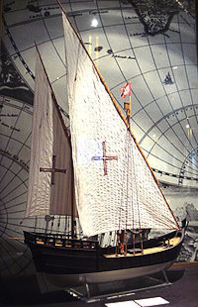
Model of a Portuguese carvel. Picture source PHGCOM
Now we have the speculation out of the way we can move into the realm of fact.
JANSZOON 1606: Captain Foley, author of the book ‘Reef Pilots’ (1982) suggests that ‘to the Dutch belongs the credit for the first sustained contact with the Cape York Peninsula’.
In March 1606 Dutchman Captain Willem Janszoon (1570-1630) in the Duyfken approached from the west and landed on the west coast of Cape York Peninsula near the present town of Weipa. From this landing he sailed south to a cape he named Keerweer (‘turn around’ in Dutch), turned and returned north and landed on the Prince of Wales Island. It is thought that the reason he did not continue south is because he didn’t like the country. It was swampy, difficult to get ashore for fresh water and the locals were not very hospitable. Ten of his men were killed on various shore expeditions. Janszoon called the land he discovered ‘Nieu Zeland’ after the Dutch province of Zeeland, but the name was not adopted. The name was later used by Abel Tasman for the land mass we now know as New Zealand.
 Janszoon thought the waters to the east of Prince of Wales were nothing more than a deep bay on the coast joining up with PNG so he turned and headed for Batavia in the East Indies, oblivious to the existence of the strait.

Replica of Duyfken. Image from Duyfken Replica Foundation web page.
EXPLORERS QUIROS and TORRES 1606: At around the same time the Duyfken was plying waters to the west of Torres Strait a three ship Spanish flotilla under the command of Portuguese Pedro Fernandez de Quiros was approaching from the east in search of the Great South Land. The three ship flotilla left Callao in Spanish Peru in December 1605 and reached a group of islands in May 1606 which Quiros named La Australia del Espiritu Santo (now Vanuatu, formerly New Hebrides). He incorrectly assumed he had sighted the east coast of the Australian mainland and was thus anxious to return to Peru and announce the news. Quiros used the word Australia as a compliment to the House of Austria to which the King of Spain belonged.
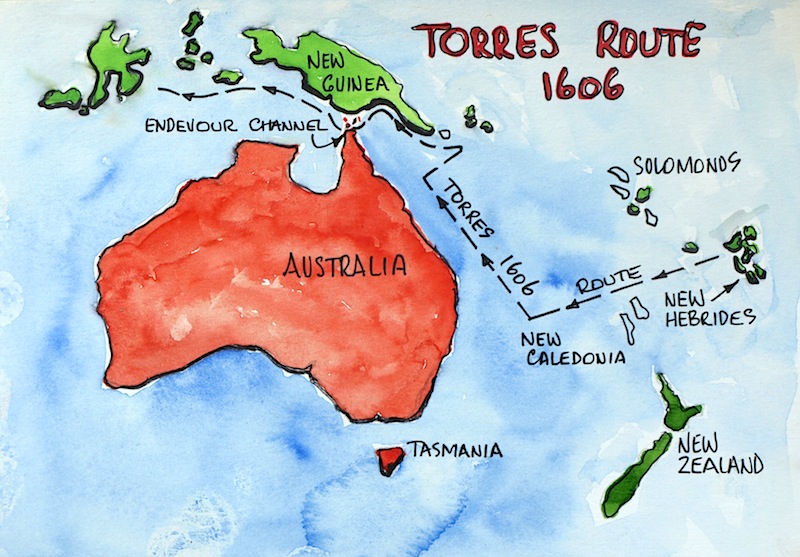
Torres route suggested by Capt Brett Hilder in 1980.
Whilst in the New Hebrides area Quirós became separated from the other ships, one of which was under the command of Luís Vaez de Torres. Quiros, not being able to find the other ships, sailed off to Acapulco in Mexico where he arrived in November 1606. After the separation Torres remained at Espiritu Santo for fifteen days before opening sealed orders the Viceroy of Peru had given him in the event of the ships being separated. The orders were straightforward: he was to sail to Manila via the north coast of New Guinea.
For many years it was assumed that Torres took a route close to the south coast of New Guinea, (he did not sail to the north of PNG as winds were unfavourable) but in 1980 the Queensland master mariner Captain Brett Hilder demonstrated that it was much more likely that Torres took a southerly route through the channel now called Endeavour Strait. If this theory is correct, Torres would certainly have seen Cape York, the northernmost extremity of Australia although he never laid claim to the fact. The exact location of Torres Strait was not made public by the Spanish as they considered making it known would have assisted their rivals and as well they were losing interest in world exploration and colonisation.
DUTCH CARSTENSZ and VAN COLSTER: In 1623, Carstensz was commissioned by the Dutch East India Company to lead an expedition to the southern coast of New Guinea to follow up the reports of land sighted further south in the 1606 voyages of Willem Janszoon in the Duyfken.
Carstensz and Van Colster set sail from Amboyna in the Dutch East Indies with two ships, the Pera and Arnhem (captained by Willem Joosten Van Colster). The ships travelled along the south coast of New Guinea then headed south to Cape York Peninsula and the Gulf of Carpentaria. In April 1623 Cape Keerweer was passed. Landing in search of fresh water, Carstensz encountered a party of the local indigenous Australians describing them as “poor and miserable looking people” who had “no knowledge of precious metals or spices”.
On 8 May 1623, Carstensz and his crew fought a skirmish with 200 Aborigines at the mouth of a small river near Cape Duyfken he named Carpentier River. Carstensz also named the Gulf of Carpentaria in honour of Pieter de Carpentier, the Governor-General of the Dutch East Indies at the time.
Whilst researching the Carstensz involvement in the discovery of Torres Strait I solved a personal puzzle and that related to an untitled image in a coffee table book I have showing dramatic geological wonders of the world. The untitled image shows a mountain and I have always wondered where it was. At last the puzzle has been solved. It is the Carstensz Pyramid, a glacier-clad mountain in Irian Jayan sighted by the explorer during his traverse through the strait. When he returned to Europe and reported that he had sighted snow on a mountain near the equator he was ridiculed as no one believed that such a phenomenon could exist.

Carstensz Pyramid. Reminds me of the Geryons in the SW Wilderness of Tasmania. Photo by Alfindra Primaldhi via Wikipedia.
Carstensz Pyramid stands at 4,884 metres above sea level and is the highest mountain in Indonesia and the highest on the island of New Guinea.

The Carstensz Pyramid (also known as Puncak Jaya) is one of the world’s most difficult climbs.
Carstensz Pyramid was first climbed in 1962 and since then expeditions to the summit occur on a regular basis. It is in remote wild country and difficult to get to.
EXPLORER GONZAL: According to Captain Foley, author of the book ‘Reef Pilots’, another attempt was made in 1756 by Dutch explorer Gonzal to locate a deep channel through Torres Strait but his attempt was also unsuccessful. He did however sight Prince of Wales Island and reach Possession Island before reversing course. Another historian believes Gonzal may have reached Wednesday Island before turning back.
TASMAN 1642/1643 & 1644: Abel Janszoon Tasman (1603–1659) was a Dutch seafarer, explorer and merchant, best known for his voyages of 1642 and 1644 in the service of the United East India Company. He was the first known European explorer to reach the islands of Van Diemen’s Land (now Tasmania) and New Zealand, and to sight the Fiji islands. His navigator mapped substantial portions of Australia, New Zealand and some Pacific Islands. Tasman’s 1644 brief was to find and map a passage through the waterway between the Australian mainland and PNG but he failed to complete the task. The map below shows his attempt.
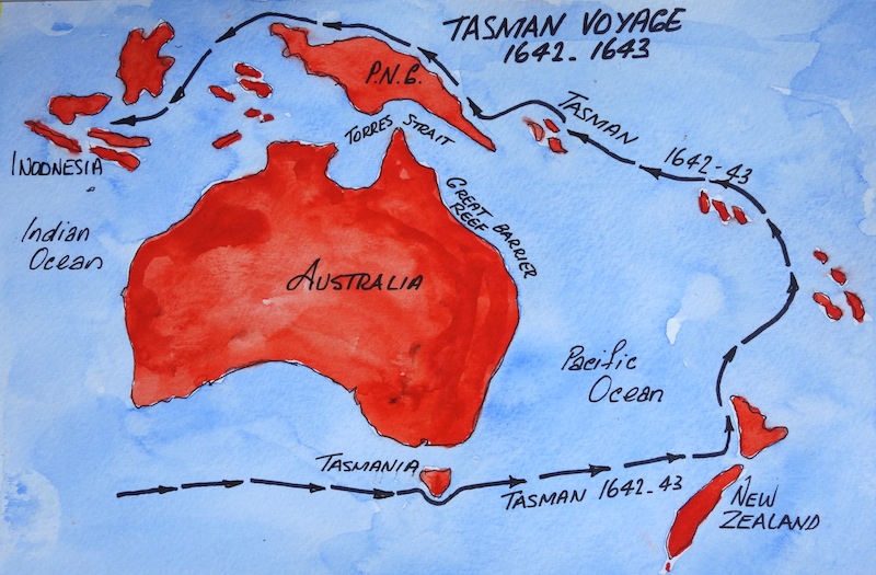
Tasman voyages.
JAMES COOK 1770: Lieutenant James Cook was the first European (that’s if we do not accept the Mendonca theory) known to have explored the east coast of Australia. Cook had been sent to chart the transit of Venus from Tahiti and after the transit business he continued west and charted much of the Australian and New Zealand coastlines. On the 19th of April 1770, the crew of the Endeavour sighted the east coast of Australia and ten days later went ashore in a bay located in Sydney’s southern suburbs. Cook named the bay Botany Bay after the expedition’s naturalist and botanist Sir Joseph Banks. Cook and Banks were not only fascinated by the botany of the area but by the indigenous folk as well. Cook wrote in his journal, ‘these people may truly be said to be in the pure state of nature, and may appear to some to be the most wretched upon the earth; but in reality they are far happier than … we Europeans’.

Captain James Cook’s voyage to the Great South Land.

Replica of H.M. Bark Endeavour. Image by John Hill via Wikipedia.
Australians of my generation well know about the exploits of Captain Cook. We had it drummed into us at school and because of this I erroneously assumed that there would be nobody in Australia who would not know about him. The error in my thinking came to light when we took two Aboriginal friends from East Arnhem Land to our homeland (Tamworth) in 2007. Our friends, Moses and his wife Marrawuy had never been out of the Northern Territory so when we took them to Sydney its size and the crowds overwhelmed them. Bev and I took them to most of the touristic sites and when sitting on the Opera House steps Moses asked ‘where are all the blackfellas?’. I answered the question by explaining the arrival of Captain Cook and events following his arrival. Our friends had never heard of Captain Cook and the subsequent commandeering of blackfella country.

Moses and his wife Marrawuy, Bev and me on the Opera House steps at Bennelong Point, Sydney.
Bennelong Point is named after Woollarawarre Bennelong (c1764–1813). Bennelong was one of the most significant Aboriginal figures in the history of Australia post-white settlement. As a senior member of the Wangal tribe he was one of a number of Aboriginal men captured by Governor Arthur Phillip (first Governor of New South Wales and founder of the settlement which became Sydney) as part of his plan to better understand local Aboriginal dialects and customs. Quick to adapt to the English way of life, Bennelong soon assumed an English way of dress and language. He took an active role in teaching the white settlers Aboriginal customs and language and his part as an intermediary between the English and Aboriginal people was crucial. Sydney’s Bennelong Point was the site where he asked Governor Phillip for a hut to be built for him. The historic site is now home to the iconic Opera House. In 1792 he sailed with Governor Phillip to England to be presented to King George III. After a long delay he returned home on a ship with Governor Hunter but arrived in poor health and a broken spirit. Disenchanted with European colonisation and alienated from his own people he was constantly intoxicated and in tribal battles. Bennelong died alone at Kissing Point (just to the south of Sydney) in 1813.

Are Moses and Marrawuy sitting where Bennelong once lived in a hut?
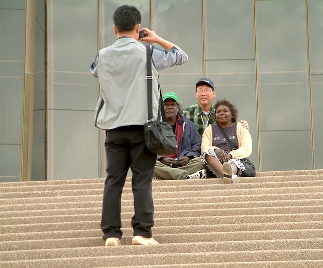
Moses and Marrawuy were a great hit with tourists.
Moses passed away in his home country in east Arnhem Land in 2013 from too much indulgence in white man vices, alcohol & nicotine; this is why I refer to him as a ‘lost warrior’. When we first met him he really was a true warrior and bushman. He could make a spear as easily as we butter a slice of bread and a truer eye I have never seen, I once saw him hit a rabbit in the headlights of our car with a VB bottle from fifteen metres away.
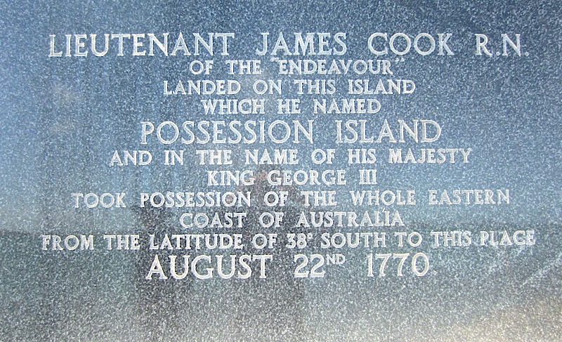
After Botany Bay Cook charted the east coast of Australia to its northern extent and on 22 August at Possession Island in the Torres Strait proclaimed in the name of His Majesty King George lll the whole Eastern Coast Australia.

Endeavour Strait is clearly marked at the bottom of this nautical chart. Possession Island is to the northeast of Heroine Rock in the centre of Endeavour Strait.
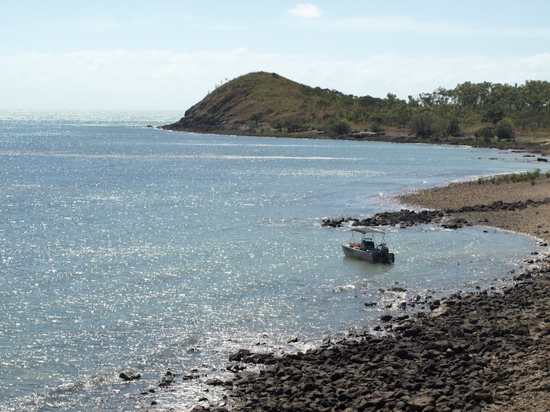
Possession Island.
I’m guessing that Cook would have anchored the Endeavour off this beach and his party would have come ashore at this very spot same spot where we are anchored. The photograph was taken from the spot where Cook hoisted the English colours and made his proclamation.
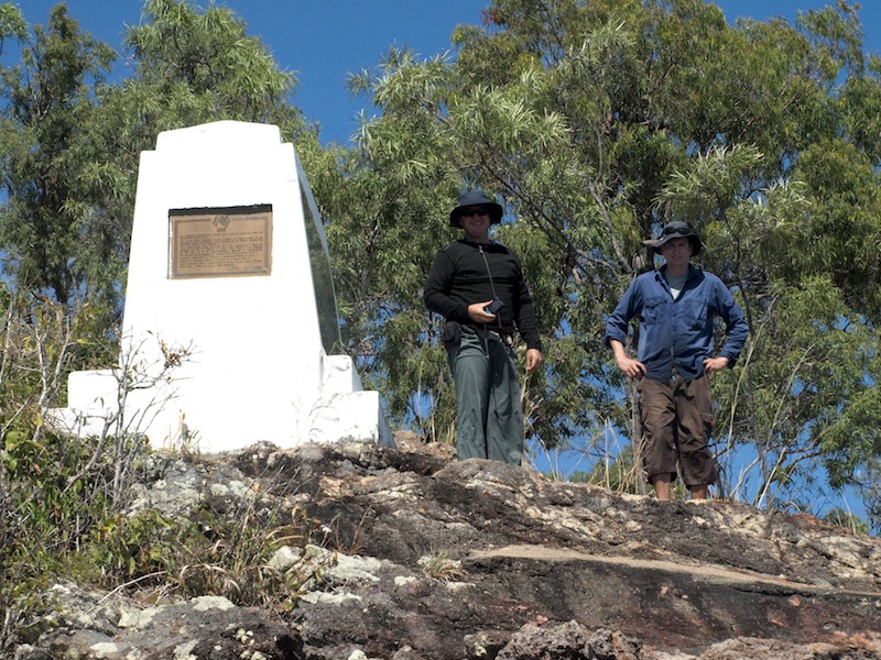
Possession Island monument.
There have been a number of cairns and monuments at this site but all were vandalised. No doubt some people objected to the fact that Cook simply declared the Australian landmass as belonging to England. The monument above was erected as a bicentennial project and is almost indestructible. The making of history such as in the case here is, I believe, part of a country’s evolution. We might not like it but that is how it is. The ones with the guns.
A clear statement.
Leaving Possession Island Cook made a landing on a rocky island he called Booby Island and then made his way to East Timor feeling, I imagine, rather chuffed with himself that he had found a passageway through southern Torres Strait. Cook named the channel Endeavour after his ship and Torres Strait after the Dutch navigator Torres.
After Cook came a number of English seafarers who were not necessarily explorers. They were shipwrecked sailors heading west, convicts escaping from the tyranny of penal settlements down south and more notable characters such as the British Naval Commander William Bligh.
In 1787 Bligh passed through the straits following the infamous Bounty munity. Bligh was set adrift without compass or chart near the island of Tofua (west of Tahiti) in a seven-metre launch with eighteen loyal seamen and he managed to cross the Great Barrier Reef then traverse northwards following Cook’s route. Bligh did not enter the Endeavour Channel but continued north, turned west and passed through deep waters just to the north of Prince of Wales Island. The passageway Bligh pioneered later became known as the Prince of Wales Channel. Most international deep draft vessels passing through Torres Strait today use this channel.

Bligh’s open boat journey.
Having experienced two metre swells (considered calm) on the open ocean in Torres Strait it is beyond belief that eighteen men in a seven metre boat could survive the gruelling sea conditions they were presented with.

The mutineers casting Bligh and loyal seamen adrift.
Soon after Bligh passed through, escaped convicts William and Mary Bryant with their two children and seven other convicts successfully escaped from Port Jackson (Sydney). They sailed north staying close to the coast, passed through Torres Strait and eventually reached Timor. The journey took them 69 days and they covered 5,236 kilometres (3,254 miles). Imagine that! Sometimes going just a few kilometres with kids in the back of the car is bad enough, let alone 5,236 kilometres in an open boat!
The escape was reported thus: ‘Today 8 men with 1 woman and 2 Children Convicts toke a kings boat of 6 oars with a large quantity of provisions… it was Supposed that they intinded for Bativee but having no vessell in the habour thare was no Pursueing them so thay got Clear of, but it is a very Desperate attempt to go in an open Boat for a run of about 16 or 17 hundred leags and pertuclar for a woman and two Small children… but the thoughts of Liberty from Such a place as this is Enough to induce any Convicts to try all Skeemes to obtain it as they are the same as slaves all the time thay are in this country’. (From Cook, J. 1993 To brave every danger: the epic life of Mary Bryant of Fowey, highway woman and convicted felon, her transportation and amazing escape from Botany Bay. London: Macmillan).
By the late 1700s most ships leaving Port Jackson were heading for India, China or the Dutch East Indies and if they went via Torres Strait these ships could save some hundreds of kilometres compared to going the long way round to the north of PNG. However many captains were hesitant about navigating through the torturous waterway but Captain Bampton was not one of them. In 1793 Captain Bampton sought and was awarded a contract from the Governor in Port Jackson to go to India and bring cattle, meat and rice to the colony and because the contract was time based he decided to go via Torres Strait. In his ship, the Shah Hormuzear, he negotiated the Barrier Reef and passed through Torres Strait and arrived in India seventy-two days after leaving Port Jackson. Previously, Port Jackson to India via the Solomon Islands and to the north of PNG (the long way round) took up to one hundred and eighty days, so the time-saving justified the risk of going via Torres Strait.
As time passed, more and more seafarers began traversing Torres Strait and another explorer, whose exploits we learnt about at school, was Matthew Flinders (1774–1814). In 1802 Matthew Flinders in Investigator sailed north from Sydney, passed through Torres Strait, around the Gulf of Carpentaria and continued right around Australia, becoming the first man to circumnavigate Australia.
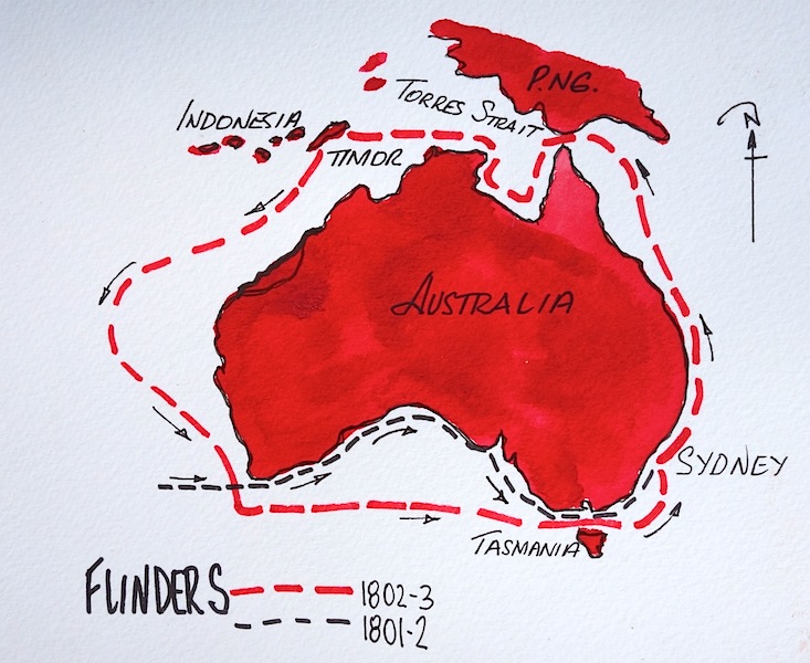 Flinders is not only remembered for being the first to circumnavigate Australia but also for sailing with Captain Bligh, surviving a shipwreck disaster and being imprisoned in Mauritius as a spy for six years from 1804. In 1814 he published an atlas of sixteen charts relating to his voyages which were used as base maps by the English Admiralty well into the 1950s. Flinders recommended that the landmass he circumnavigated be called Australia.
Conclusion of this post: This post has been very time-consuming, as tracking down who did what and when has not been easy. Some authors can be rather vague when it comes to presenting facts, which makes understanding what and when events happened difficult for an amateur historian such as myself. If any readers are more informed than I, please correct me, post your comments and I will edit the story.
Part 4 of our Torres Strait Encounter relates to the erection of navigational aids, establishment of the pilot services through Torres Strait and my once in a lifetime adventure of going out in a pilot boat to pick up a pilot from a general cargo vessel en-route from Singapore to New Zealand.
