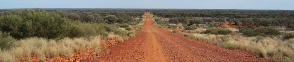
OUR JOURNEY TO TASMANIA
FROM HOME TO DEVONPORT via MELBOURNE.
October 2016.
During our peregrinations in Europe in 2015 (Odyssey#3) we thought about where we might go next to revisit our past. After some deliberation we decided not to leave Australia but to stay on home ground and visit Tasmania, the most southern state of Australia.

Tasmania
Some people say Tasmania is overseas as to get to there one has to cross Bass Strait, which can at times be a very rough overnight or daylight sea voyage. Because we were driving and had plenty of time we thought we would make a few stops along the way and one of those was the Barmah River Red Gum forest on the Murray River.
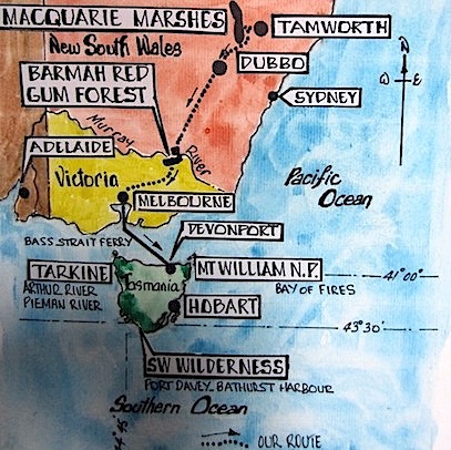
Our route to Tasmania and the location of the Barmah Red Gum Forest.
THE RIVER RED GUM FOREST, BARMAH NATIONAL PARK
Over six months in 2016 the inland regions of NSW and the whole of Victoria received record-breaking rains and thus many roads, even major highways south, were impassable. However we managed to elude the major flooded sections and make it to the Barmah National Park on the Murray River.
According to Parks Victoria, the Barmah National Park, together with the adjoining Millewa forest in New South Wales, forms the largest River Red Gum forest in the world. The complex ecology of the forest is closely linked to the Murray River and its flooding regime, creating a diverse natural habitat for a variety of wildlife, particularly waterbirds. Fortunately for us the forests were flooded and to be able to see them during a flood event was an amazing experience.
To understand why there was so much water in the forests one needs to know about the catchment areas of the Murray and Darling Rivers and where the water came from. The following map shows the extent of the Murray-Darling Basin.

Catchment area of the Murray-Darling Basin (green area).
The Murray-Darling catchment is huge, approximately 1.5 million square kilometres, twice the size of the United Kingdom’s total land mass and larger than Switzerland by 25 times. The Murray-Darling basin drains 7% of the total area of Australia and when 200 millimetres of rain fell on such a large catchment it meant rivers rose to record-breaking levels. During the deluge many riverside towns were flooded and some levees protecting those towns were on the verge of giving way or being overtopped by waters.
One levee that stood secure was around a caravan park on the banks of the Murray River on the edge of the Barmah National Park. Caravans on the riverside of the levee were not protected and owners suffered the consequences.

The levee and additional sandbags that held.

Caravans on the riverside of the levee.
In Australia thousands of people live in caravan parks on a permanent basis and I guess some of the vans in the above photograph are the only homes some people have. Cleaning up after the floodwaters receded would have been a heart-breaking task.

For us it was an unusual experience paddling around a caravan park. At the peak the floodwaters were about 200 millimetres higher than shown in the above photograph.

An historic fire truck on the wrong side of the levee.

The road was temporarily closed before the floods, now it’s permanently closed. We couldn’t open the gate!

A gracious river red gum (Eucalyptus camaldulensis) in the 650 sq km Barmah National Park.

River red gums grow along the rivers and creeks in the Murray Darling river system. The ones above would normally be on dry land.

Centuries old sentinels of the forests. These two trees are standing in about one and a half metres of water on the edge of the submerged riverbank.
A natural flooding is a powerful element and to see a wide plain under water is a sight to behold. Following is an oil painting by William Charles Piguenit (1836-1914) and in light of him being a Tasmanian I thought I would include his painting, ‘The Flood in the Darling’, in these writings.

The Flood in the Darling. Image credit; In the public domain via Wikipedia
Many stands of river red gums, particularly along the Murray River, have been exploited for commercial gain. They were harvested to fire the boilers of paddle steamers that plied the river in former days, for railway sleepers, firewood, fence posts and setts. Some streets in the city of Melbourne were surfaced with red gum setts (100mm cubes). To preserve them they were often dipped in tar.

A road paved with wooden setts. Paving roads in Melbourne with wooden setts was popular in the 1880s. In the 1950s they were removed and sold for firewood. Image credit: Z22 via Wikipedia
Fortunately the exploitation of red gums along the Murray River has all but ceased but this does not mean they are not under threat. Seventy five percent of red gums along the lower Murray are stressed, dead or dying because they no longer receive regular natural flooding. Dams and weirs along the river regulate flow for irrigation purposes and there is simply not enough water for town usage, irrigation and environmental needs, especially during times of drought. At the time of writing the Federal Government was considering reducing environmental allocations, which would exacerbate the plight of the trees. Unfortunately the game of politics in some people’s minds is more important than the survival of the Murray’s red gums. It might also be noted that some irrigators upstream in northern NSW and Queensland actually steal water, amounting to billions of litres disappearing from the system.
Not only are the red gums under threat but wildlife is as well, including the iconic Murray cod. During the late 1800s dead river gums that had fallen into the river were removed for the sake of safe navigation. The removal of the fallen trees reduced native fish habitat considerably and the introduction of European carp has had a detrimental effect on native fishes.

Murray cod. These fish live only in the Murray-Darling catchment. Image credit: Created by “Fir0002/Flagstaffotos”. The image is in the public domain provided it is not used for commercial gain. Via Wikipedia.
On the Wikipedia website, from where the above image was drawn, there is no reference as to how big the cod in the photograph was but I’m guessing it would be at least a metre long. The largest cod recorded to date measured 1.8 metres and weighed 113 kilograms. Fish of this size are rare these days.
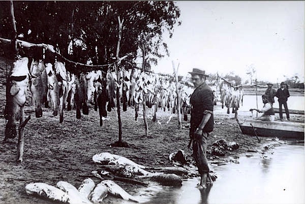
An example of overfishing of Murray cod in the late 1800s. The largest cod on the left could be fifty years old. Image credit: According to Wikipedia this image may qualify as fair use.
Many creative furniture makers use red gum timber; they do not cut down trees but gather long fallen and well-seasoned logs.

A slab of polished red gum. Image credit: Mark Anthony Boyle via Wikepedia
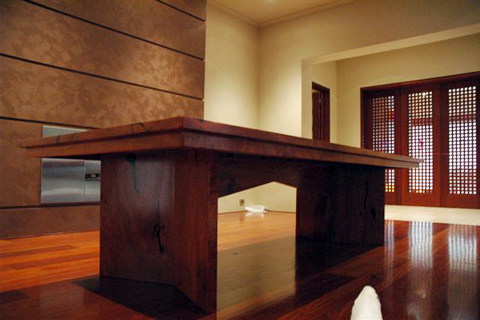
Solid red gum table. Image credit: Wildwood Designs Australia.
Wildwood Designs Australia (www.wildwooddesigns.com.au) have two showrooms in Sydney, one at Stanmore and a second at Gladesville, obviously a must visit during one of our trips to Sydney.
The botanical name for river red gum is Eucalyptus camaldulensis. Eucalyptus is from the Greek words eu-, well, and kaluptos, cover, meaning “well-covered”, describing the operculum (the cap over the seed pod) and Camaldulensis relates to the Camaldoli monastery near Naples Italy where the first specimen came to be described.

River red gum operculums. Photograph taken in dry riverbed near Alice Springs.
In pioneering days, river red gums were given the ominous nickname of ‘widow maker’ as many new chums (people new to the way of things in the bush) lost their lives to falling branches when camped under them. Branches can fall at any time but more so in summer when the tree has taken up more water, making the branches heavier.

There were three people in this tent (right image) when the ‘widow maker’ dropped a branch. Fortunately no one was killed or injured. Image credit: Discover Murray web page.
From the red gum forests we headed to the town of Bright in Victoria where there was a rail trail worth cycling. Rail Trails have been established in many parts of Australia. They are disused railway lines with the rails and sleepers gone and the ballast sealed to make a smooth riding surface.

A town on the rail trail. How could we not take a photograph of a town name like this.
Depending on who you talk to the meaning of Porepunkah is Hindi for ‘gentle breeze’ or in the local indigenous language, ‘meeting of the waters’
Two positive aspects of rail trails are more people on bikes and small businesses in towns along the way that were struggling to survive prior to the advent of the trail are doing a thriving business catering for the riders. Cyclists use energy and they need food to replenish energy expended.

A café that didn’t exist before the rail trail came into existence.

Water bottles that cyclists have left behind after a stopover at the café.
One of the larger towns along the trail is Bright and it is one of those towns where early settlers attempted to recreate England by planting English and European trees. They even introduced English birds and snails, the favourite food of the English blackbird. When were we riding the Bright rail trail the call of the English blackbirds made me think we were back riding trails in England.

Town portion of the rail trail through the town of Bright.
The trees lining the trail in the above photograph I thought were introduced silver birch but on further reading I’m not sure. If any reader knows what species they are I would appreciate being enlightened.
On this journey we are carrying more equipment than we would if we were riding bikes only. The following photograph shows our rig. The pop-top camper is homemade and has served us well for the past twenty years.

Our pop-top camper trailer and annexe set up. The foldup bikes stand on top of the camper roof.
One of the luxuries we have on this trip is our fireplace. Following is a photograph showing my homemade fireplace.

Our above ground fireplace made from an old oil drum cut in half.
Our above ground fire setup has a lot of advantages. Not only does the fire not kill the grass but it can be moved if there is a wind change thus avoiding annoying smoke, it is at a convenient height and long logs can be fed into the fire so cutting wood to length is avoided. Also it is possible to grill cheese on toast by placing the toast under and close to the bottom of the drum (where the kindling is under the fire in the above photograph).
It is impossible for travellers like us not to have a campfire and a camp oven brew up which is usually a stew similar to Hungarian goulash or Moroccan tagine. The camp oven is also used for cooking bread, damper and puddings.

Camp oven (left) with freshly baked bread and a feed of fish, vegetables and potatoes (wrapped in aluminium foil and buried in ashes).
Melbourne is a great cosmopolitan city and whenever we pass through Melbourne we allocate time for shopping and cycling. Shopping is nothing like the shopping advocated in inflight magazines. Shopping for us is visiting the outdoor shops to replace worn out wilderness gear and to make a pilgrimage to Camera Lane in Little Bourke Street. Many of the old photographs appearing in this post of past wilderness adventures were taken with medium format cameras using colour transparency film, all purchased at Camera Lane.
CROSSING BASS STRAIT.
The 350 kilometre wide Bass Strait crossing can sometimes be rough, not Bay of Biscay rough (documented in a blog post in May 2015) but it can be rough enough to make one lurch about like a drunk when walking. There are conflicting reports as to the biggest wave recorded in Bass Strait. One report suggests a twenty metre high wave washed by the Spirit in February 2005 but then a Bureau of Meteorology Waverider buoy measured the highest at eighteen metres. Regardless, a wave of anything over ten metres would be a force to be reckoned with.

Spirit of Tasmania 2 on a crossing of Bass Strait. This photo was taken by Bev from the Spirit of Tasmania 1 when the ships passed each other in the middle of Bass Strait.

The Spirit of Tasmania docked in Devonport Tasmania.
There are many narrow river ports in the world where huge ferries dock and turn. Devonport is one of them. It’s quite an entertainment to watch this huge vessel turn in the narrow river.
Bass Strait is named after George Bass who, with fellow marine explorer Matthew Flinders, circumnavigated Tasmania in 1798. Flinders wrote of Bass, when recommending the naming of the strait: ’for the extreme dangers and fatigues he [Bass] had undergone, in first entering a whale boat, and to the correct judgement he had formed, from various indications, of the existence of a wide opening between Van Diemen’s Land and NSW’. New South Wales at the time encompassed half of the Australian continent and where Melbourne is now was therefore located in NSW.
The vessel that Bass and Flinders used for the circumnavigation was the decked colonial sloop ‘Norfolk’, a small vessel of around twenty-five tons. There is debate as to its exact tonnage but regardless, it was a very small vessel and to sail around Tasmania in such a boat was tantamount to attracting the eye of the Grim Reaper.
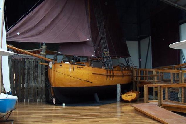
The replica ‘Norfolk’ built for the 1998 re-enactment of the Bass and Flinders 1798 voyage of discovery. Image in the public domain via Wikipedia.
It was six years after the 1798 circumnavigation of Tasmania by Bass and Flinders that convicts and their guards began arriving in Tasmania. Soon after, sealers, whalers, timber getters and free settlers arrived and since then there has been a constant string of visitors visiting Tasmania to marvel at its wilderness and to exploit its natural resources. Naturally we come to experience the wilderness and to a lesser degree its history and exquisite craft and art works.
Spending a long period in the Tasmanian wilderness is not for the delicate as one is exposed to many discomforts, including the difficulty in predicting the changeable weather. If the weather turns bad days can be spent confined to one’s tent. However putting up with the discomforts such as limited food and the possibility of being wet for prolonged periods is part of the experience and it makes one feel alive.
Our longest stint in the wilderness was for 23 days when kayaking at the furthermost southwest point of the wilderness in the Port Davey and Bathurst Harbour area. During that time, even though it was mid summer, there were times when we were wet and cold and adding to the discomfort we experienced the effects of a tsunami wave, which made kayaking on the open seas a tad risky.
Following are some images relating to our sea kayaking and walking expeditions into the wilderness over the years. In retrospect, the period spent kayaking in the southwest was a once in a lifetime experience and it goes down as one of our greatest adventures.

Southwest Tasmania. This relief map shows how mountainous Tasmania is and our route from Kettering near Hobart to the southwest.
The black line on the map shows the route taken by the fishing boat that transported us to the Southwest Wilderness for our 23 day adventure. The journey took approximately twelve hours. The southwest is true wilderness, no roads, power-lines, fences or buildings; the only exception is a few walkers’ huts.
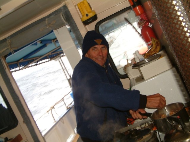
Cooking lunch under rolling conditions on the motor vessel La Golondrina that transported us and our kayaks to the southwest in 2004.
Taking a trip to the SW Wilderness is a once in a lifetime experience. Contact Morrie at Kettering Tasmania (webadmin@kettering.tas.au) if you care to indulge yourself. When Morrie picked us up after the 23 day expedition he took us fishing and cooked us a baked dinner on the way back to Kettering, much appreciated after living on dried food for three weeks.

Some of the food taken on our kayak trip to the Tasmanian southwest in 2004.

Hardy expeditioners in Bathurst Harbour.

Seals in the south.

Preparing two of the three sea kayaks we took to the SW Wilderness. The highest mountain on the horizon is Mt Rugby.

Toby and Tim, our two sons, standing on top of Mt Rugby. Bathurst Harbour in the foreground and the Southern Ocean in the distance.

Bathurst Harbour and Mt Rugby Southwest Tasmania

Lobster for breakfast during our kayaking trip in the SW Wilderness.
The lobsters were given to us by a professional fisherman and because at the time we were running short on food the donated crustaceans were much appreciated. The fishermen who work the Southern Ocean for abalone and crayfish are very friendly towards sea kayakers, I expect they consider they have to look after visitors to their territory. They draw their vessels up next to the kayak and ask whether we have enough food and water and it is a comforting feeling knowing somebody is concerned about your wellbeing.

Bev keeping watch over our drying socks.
The socks were made from Gore-Tex lined with wool and are reputed to be waterproof. One morning when I pulled one on it felt a little squishy. Removing it I found it had been fly blown. All three pairs were full of maggots! Apparently mother blowfly was attracted by the odour and dampness, she probably thought it a good place to deposit her charges. Just one of the many little discomforts experienced when walking in the wilderness.
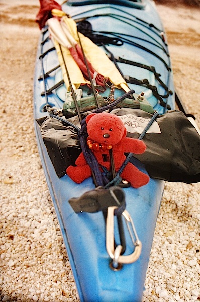
Tbear on the front of one of our kayaks and ready for the wilds of the Southern Ocean.
Tbear no longer travels with us as he jumped off the handlebars of my bike in Dresden Germany and was lost. To read about the loss of Tbear search Dresden Part 2 Odyssey Part 2 and scroll down to ‘An attempt to find Tbear’. Tbear has now been replaced with another red bear, BBear.

BBear admiring the view on the east coast of Tasmania.

A tranquil scene in Bathurst Harbour

A perfect evening in the southwest wilderness. The fire is below the high tide mark.

An island off the southwest coast. Kayaking past an island like this makes one think about how insignificant we are. The power of nature can be seen here in the folds of the rock.

Our eldest son Tim and Bev having a cuppa near a wintry Lake St Clair.

A primitive hut, in the Tasmanian wilderness where walkers are able to stay.
The ladder is to access a flap on the chimney and when closed keeps possums from entering the hut. Huts like this are a welcome sight at the end of a day’s walk, especially when you are wet. Fires are not permitted in the wilderness areas except in huts such as this because a fire in the open could set the peat bogs alight, which are known to burn for a very long time.

The Western and Eastern Arthurs
The track to the Arthurs stretches across the buttongrass plains, a walk that we undertook on one of our trips to Tasmania. Our sons walked the length of the Western Arthurs and we walked along the base until we ascended the eastern section, perhaps a less gruelling walk. There we camped by the picturesque Lake Promontory, high up above the valley below.

Lake Promontory Eastern Arthurs

Kayaking on Lake Pedder, another of our adventures.

This is how photography was prior to the digital revolution. Twelve rolls of 120 film (left of compass).
The above photograph shows what was left over and brought out after a 10 day walk in the Walls of Jerusalem…a small piece of cucumber, some broken biscuits, a sliver of Kraft cheese (below compass), one muesli bar and, most importantly, the exposed 120 roll film.
That’s the end of this post. Following posts will show the Tasmania we have come to know over the years. The next post will take you to the ‘Edge of the World’ and the Tarkine Wilderness area on the west coast.
Leave a comment if you wish and if you want to be alerted each time we do a post click on FOLLOW.

Wow it is so beautiful, I am sure you had good time in this trip.
Salah
Yes we did. You must make a trip to Tasmania some time you will enjoy it too. if we can help you with destinations etc let us know.
Regards Fred and Bev
Impressed with the lack of waste of the food supplies on your trip! Great pics too by the way.
Sara
Thankyou for your comment. Yes we didn’t have a lot of waste to bring out from the SW. Some of the pics were taken with roll film, using roll film was a love of labour no doubt. Mind you as you well know the digital scene is easier. Spoke with Morrie the owner of the boat that took us to the SW and he tells me he is retiring, however he has people interested in taking the business over so we might one day do the trip again.
Fred and Bev
Hi guys,
Another great post and great photos.Loved your visit to the Barmah National Park.
Love Kevin and Sue
Kevin and Sue
Good to hear from you again. We are trying to work out to where next. We will let you know when we make up our minds.
Fred and Bev