OUR JOURNEY TO TASMANIA — LAND of the ANTIPODEANS
SOUTH COAST CONSERVATION AREA
SOUTHPORT LAGOON
Our 2016 journey saw us back in the southern part of Tasmania. The plan was to take a canoe trip across the water from Southport to the peninsula to the north of Southport Lagoon. I have always wanted to go to this area after seeing it from the air on a trip to the SW wilderness. In 2000 we flew along the south and east coasts of Tasmania en route to Hobart after having spent time walking the Southwest Cape region. On the return flight we saw for the first time Federation Peak and the remote Southport Lagoon. The previous map shows Southport Lagoon and Federation Peak (at the bottom right corner of the map) and the following map shows our flight path from Melaleuca. At Melaleuca there is a dirt airstrip suitable for light aircraft and is the only airstrip in the SW Wilderness.


Federation Peak.
On a number of occasions I have spotted from the air wild remote places and have told my family of my desire to go there. Both Southport Lagoon and Federation Peak were two of these places. Fortunately I was able to walk into Federation Peak, or the Fang as it’s affectionately known, with my eldest son Tim and my nephew Wes in 2004. I will relate the Federation Peak story at some time in the future, all I will say at the moment is it involved walking in heavy rain for eight days. When it’s so wet leeches come out and start looking for blood. One night during the walk I awoke to find a leech in my mouth, I was chewing it like one would chew hard liquorice!
For those who have not had close contact with leeches I can assure you they are not a creature you want to get intimate with as they are blood suckers and the very thought of one hanging off you is revolting. Leeches are usually around 70 millimetres long but when extended can be as long as 150 millimetres. The longest I have come across was a horse leech, around 100 millimetres.
In my teenage years the highlight of the week was to go to the movies on a Saturday afternoon. Going to the movies was referred to as going to the ‘fleas and itches’ as the cloth horsehair stuffed seats were a natural habitat for fleas. After returning home my mother made me get undressed in the bath ensuring any fleas I brought home on my person would be shaken into the bath and washed down the drain. I mention this now because one afternoon the movie ‘African Queen’ was showing staring Humphrey Bogart and Katherine Hepburn. In the film Bogart emerged from a river with huge leeches all over his body. To view the scene, search ‘leech scene African Queen’ on the web and you will understand how revolting leeches are.

A leech looking for blood. Image credit: Parks and Wildlife Tasmania.
For thousands of years leeches were used as an adjunct to bloodletting, they were applied to humans to cure various ailments. Today they are used in clinical applications, especially in plastic surgery.
Our method to remove leeches was to put salt on them but recently we were told that the best method is to quickly slide a knife under them and flip them off. Over the past twelve months we have had a number of leeches on us and there is no doubt the sliding knife method has proved successful as the leech sucking spots have not become infected. This can happen if a leech is forcibly removed because it regurgitates the contents of its gut into the bite. These contain bacteria and can cause secondary wound infection.

My swollen infected hand a day after a leech was removed using the salt method.
Back to our journey to Southport Lagoon,following that digression.

Southport Lagoon. The photograph was taken on the return flight from Melaleuca to Hobart in 2000.
Accessing Southport Lagoon is nowhere as difficult as getting into Federation Peak, however from a logistics point some planning is required. From the sea it’s almost impossible as the bar into the lagoon is dangerous and a 4WD track in from the west that we drove once is unbelievably difficult, taking nearly two hours to traverse eleven kilometres and then, where the track terminates, it is nowhere near the lagoon entrance.

Map showing King George Rock, our Safe Haven camp and Southport Lagoon.
The only feasible option for us this time was to walk in from the southern side of Kingfisher Bay and this meant we had to canoe across Kingfisher Bay from Southport. The point at which we intended to commence the walk was where an old narrow gauge railway line ended at the Deep Hole jetty. Choosing this approach meant camping for two nights.
The railway line was used between 1919 and 1975 to transport high-grade limestone from a quarry west of Lune River to Ida Bay and on to the Deep Hole jetty on the southern shores of Kingfisher Bay. The limestone was shipped away and processed to make carbide. Carbide when mixed with water produces acetylene which when lit produces an intense white light.
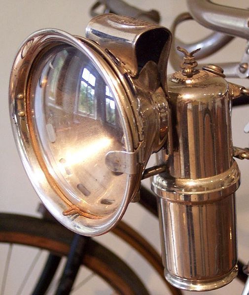
Carbide lamp mounted on a bicycle circa 1910. Image credit: German Wikipedia
Today, a small WW2 diesel locomotive pulling open-sided carriages takes tourists from a station at Lune River to the banks of Ida Bay and terminates at Deep Hole jetty. From the old jetty site tourists have the option of walking out to Southport Lagoon, however after having walked the track it’s fairly obvious that few tourists take up the option as for most parts it is overgrown and hard walking.

The Ida Bay train ran past the end of the beach on which we camped.
The train and carriages are not upmarket and if the reader wants a low-key interesting day out it is well worth climbing aboard. Bev and I travelled on the train in the 1980s and between then and now little has changed, which is rather refreshing. It would be possible in a day to take the train, walk out to the lagoon and catch the last train back to Ida Bay.
The canoe trip across Kingfisher Bay was a little frightening as part way across a stiff breeze sprung up and when the side-on swell threatened to swamp us we decided to abandon our course and make a run for a sheltered inlet. The canoe we used on this trip was new to us and we got to thinking we would feel much more secure in one of our low-centred gravity sea kayaks.

The fibreglass Canadian canoe that was new to us.
To access the sheltered spot meant crossing a bar running between what is referred to on the maps as ‘The Narrows’. The tide was running out through the narrow gap and with the wind blowing in the opposite direction it made for a far from pleasant crossing. Regardless, in true adventuring spirit, we managed the crossing without being swamped and arrived safely at a beach and the spot where we chose to camp we nicknamed Safe Haven Camp. As is often the case in Tasmania the beach was pristine, no flotsam or jetsam, no footprints other than those of the local residents…soldier crabs, oystercatchers, Pacific gulls and pademelons (small wallaby).

Pacific and kelp gulls are hard to tell apart so below is a sketch from my Birds of Tasmania sketchbook circa 2005.

Sketches of Pacific and kelp gulls.

Safe Haven camp in the dunes. The plastic seats are out of the canoe.
Dense bracken fern on the high banks forced us to camp lower in the sand dunes and after a little scratching we levelled a spot and pitched our tent under an acacia. When preparing the tent site I disturbed a nest of Jack jumper ants (native to Tasmania) and Bev uncovered a scorpion, both these critters can give a nasty bite.
A bite from a Jack jumper or a scorpion can prove fatal to people who are allergic to their toxins. Those who are allergic to the bites might find a blister appears and the bite area aches. If this occurs it is best to seek medical help.

Jack jumper, approximately 20 millimetres long. Image credit: Maria Fletcher via Tasmania’s Journal of Discovery.

A scorpion in defensive mode. Its stinger is on the end of its tail. In Australia they can grow to 100 millimetres long. Image credit: Insect-R-Gon.

View from our Safe Haven camp.
At the southern end of the beach where we camped there are a number of Aboriginal middens containing mostly oyster shells. Nearby the middens there are growing oysters awaiting harvest, the size of a fist. It must be said though that one has to be careful eating wild oysters in Tasmania as they can be contaminated with bio-toxins, which is related to algal bloom levels in the water. Commercial oysters are not immune to being affected but the ones for sale have been tested for contamination and are therefore safe to eat.

Aboriginal midden comprising mostly oyster shells.
Some middens in the SW wilderness present themselves as huge hills and lying on the surface of one midden we saw the jaw of a long extinct thylacine (Tasmanian tiger). The following photograph shows a sketch from one of my notebooks of the said jaw.

Sketch done on a midden in the SW Wilderness.

Tasmanian tiger (Thylacine) now long extinct. The above photograph is of a print, which was hanging in a shop window. Image credit: Thanks to the artist whoever she/he may be.
The last thylacine died in Hobart Zoo in 1936. There are advocates that say the tiger is still wandering the wilderness but I doubt it as there are many walkers in the wilderness these days and a positive sighting is yet to be confirmed. However, the hunt goes on.
Our night meal at our Safe Haven camp comprised vegetables, pasta and eggs. Prior to leaving home I sun-dried a quantity of vegetables which, when soaked and cooked, make a great meal. All vegetables can be sun dried. Some, such as carrots, are best blanched before drying. Eggplant (soaked in soy sauce) is particularly tasty. Sun drying vegetables is best done in low humidity climes, the following image shows how it is done.

Vegetables spread thin on the makeshift drying table, an old bed with shade cloth on top.
The legs of the drying table are standing in tins filled with water to prevent ants travelling up. Over the table on which the chopped vegetables are scattered is a suspended mosquito net, which keeps the birds from helping themselves. It is best to give the vegetables three full days of hot sun and they must be covered at night so they do not absorb damp night air. When they appear to be dry place them on baking trays and with an oven set to low heat dry them out completely.
About ten hours prior to cooking soak the dried vegetables in water. If you are setting off on a walk or kayak trip simply put them in a bottle with water the morning of the trip and by day’s end they will be ready for cooking.

Dried vegetables ready for our meals.

A nutritious meal in our sandy camp.
In summer total darkness at these latitudes does not come until around ten but we didn’t wait until dark before going to bed. Retiring early is not uncommon, especially when it’s cold and wet. Getting twelve or more hours sleep combined with drinking only pristine wilderness water, breathing the cleanest air in the world, eating little and getting a lot of exercise brings one into a state of health not experienced when at home. There is no need to go to a health farm, simply go for a wilderness camp.

Snug in our 2 person tent in one of our past wilderness camps.
It is comforting sleeping in such a small space, it’s womb-like and secure until an external force activates a mood change. The mood changer for us at our Safe Haven camp was a very strong wind, which sprang up shortly after midnight. The wind hammered the side of our tent and because it was a little difficult to sleep we talked and reminisced about similar nights we have had in the past. Bev and I have been travelling and camping together for 45 years so we had a lot to talk about.
As dawn came to us the wind continued so we decided the best plan was to join the old railway line and walk to its terminus at the Deep Hole jetty rather than canoe there. From there we would walk further on to the northern end of Southport Lagoon.

Bev walking the 2 foot wide track from the beach to the terminus at Deep Hole. It’s obvious this is no high-speed line.

End of the Ida Bay railway line at Deep Hole.

Deep Hole where a jetty for loading limestone once stood. Southport village is across the water.

End of the Ida Bay line. The grey ballast is high-grade limestone that was used to make carbide.

Deep Hole jetty in days gone by.

Remnant limestone.
The walk from the terminus to the lagoon was a typical wilderness track. There were no improvements and in places the track was how tracks were before they were improved to suit the ‘high-heeled brigade’, tourists who attempt to walk some tracks in totally inappropriate shoes. The track passed through eucalypt woodlands, button grass plains, low coastal heath and across the occasional peat bog swamp. Fortunately they were not excessively wet.

The beginning of the track to Southport Lagoon and Bluff.

The track to Southport Lagoon across the button grass plains.
The beach bordering the lagoon was dazzling white and curved to the mouth of where the lagoon flows into the sea. I was anxious to walk to the mouth but after being blown over a couple of times we turned and headed back into the shelter of the coastal heath. Before returning to shelter we managed a few photographs.

A windswept Bev and beach at Southport Lagoon.

Looking west from Southport Lagoon. Note a little winter snow remaining on Mt La Perouse.
The walk to Southport Bluff was marvellous and again we passed through eucalypts, melaleuca woodlands, tea tree swamps and sand dune heath. Getting through the scrub at the edge of the beach was a challenge as the track was completely overgrown. Breaking through onto the beach was like passing through a curtain into another world. Before us lay a magnificent unspoilt vista.

The walk through the wildflowers to Southport Bluff.

Breaking through the curtain.

Southport Bluff beach.
When walking remote beaches it is best to walk just below the high tide line especially at this time of the year when waterbirds are nesting. On the beach walk today Bev came close to an oystercatcher nest. Hardly a ‘nest’, it was simply a depression in the sand.

Oystercatcher eggs. The dark spots imitate the colour of dry seaweed.
Oystercatchers are shy birds and if approached they move on, keeping just out of photographic range. There are two oystercatchers in Tasmania, the pied and the sooty. It is thought pied oystercatcher numbers have declined and the current population could be as low as ten thousand. Following are two images from my birds of Tasmania notebook circa 2003.

Pied oystercatcher

Sooty oystercatcher

Oystercatchers feeding.
Oystercatchers are able to prise apart bivalve molluscs (hence the name) using their special chisel-shaped bill. They also eat worms, crustaceans and insects.
The sands of the beach at Southport Bluff have not always been a place of tranquil beauty. In 1835 the convict ship George lll ran aground on an uncharted rock nearby with the loss of 133 lives.

Sinking of George lll by Norwegian artist Kund Bull (1811-1889). Image credit: Image out of copyright. Extracted from Wikipedia.
Kund Bull used artist licence when painting the sinking of the George lll. The ship was nowhere near the beach as depicted, the inaccuracy was a hotly debated point at the time.
George lll under the command of Captain Hall-Moxey sailed from England four months prior, with a total of 308 persons on board. The ship was bound for Hobart Town, Van Diemen’s Land (Tasmania) and because it was delayed en route the captain decided to take a short cut to the west of Bruny Island rather than the more regular longer route to the east of the island.
High on Southport Bluff there is a tomb in which the skeletons of the drowned and executed lay. The executed were convicts who were shot by troopers when attempting to save themselves from the wreckage.

The tomb in which the skeletons of those who died are interred.
An inscription on the front of the tomb tells the story. Because the area is fenced off due to plant quarantine and we couldn’t get closer I have taken the inscription from a Tasmanian history web page.
‘Near this place are interred the remains of many of the sufferers who perished in the wreck of George III convict ship, which vessel struck on a sunken rock near the Actaeon Reef on the night of the 12th April, 1835: upon which melancholy occasion 134 human beings were drowned.
In order to avoid being blown offshore and thus delaying arriving in Hobart Town, the master decided to enter the torturous D’Entrecasteaux Channel between Bruny Island and the Tasmanian mainland. At about 9.15 pm that evening George III hit a rock and over a period of several hours broke up in the heavy swell. The convicts were kept below to allow the women and children to be safely evacuated by the ship’s boats. The guards fired their guns in order to quell rising panic; this gunfire is believed to have killed between one and three of the convicts. Many others drowned below decks, including many of the sick in their beds. In all, 133 lives were lost in the disaster, of whom 128 were convicts.[1]
This tomb is erected by the desire of His Excellency Colonel George Arthur, Lieut. Governor, to mark that sad event, and is placed on this spot by Major Thomas Ryan, 50th Regiment, one of the survivors of the occasion’.
The sinking of the George lll and the subsequent loss of life is a little known event in Australian history. Some Tasmanians I related the story to had never heard of the event.
Unfortunately it was not possible to visit the tomb as on the bluff there are a number of rare plants and the fear is that people visiting the tomb could carry on their boots the deadly Phytophthora bacteria. Phytophthora (Phytophthora cinnamomi) is an introduced plant pathogen that causes root rot disease in susceptible plant communities. The pathogen is spread by water and infected soils.
To stop the spread of Phytophthora, wash-down stations have been installed on some tracks and prior to going into or out of the wilderness walkers are encouraged to thoroughly clean their boots. Bev and I also clean tent pegs, walking poles, camera tripod feet and even the underside of our tent.

Sign instructing walkers how to clean their boots and equipment.

An expensive boot-cleaning machine.
The procedure as shown above is: clean loose dirt/mud off boots using upended stiff brushes then place one boot at a time in the box between the vertical stanchions. Finally press the rubber bulb (top right) and a spray of root rot killer saturates one’s boot.
There is a rare plant we are always on the lookout for when we walk in the Tasmania wilderness and that’s King’s lomatia (Lomatia tasmanica). Leading botanists say it is a contender for being the oldest plant in the world. Only one cluster of fewer than five hundred plants exists. Unfortunately they are surrounded by Phytophthora. The plant is also known as King’s holly and was discovered in 1937 by Denny King who mined tin in the Bathurst Harbour area.
One reference suggests King’s lomatia is a clonal colony estimated to be 43 000 years old making it a candidate for the oldest organism on earth. Another possible candidate is a stand of the marine plant Posidonia oceanica in the Mediterranean Sea which could be up to 100 000 years old.

King’s lomatia (Lomatia tasmanica).
It is possible for the botanical enthusiast to see a potted specimen but application has to be made in writing to the Royal Tasmanian Botanic Gardens in Hobart. This highly endangered species flowers in December/January but not every year. No seeds are produced when it flowers. Cuttings strike well and take up to twelve months to develop roots.
To be able to walk in solitude along the beach where survivors from George III would no doubt have wandered was a humbling experience. As we walked we tried to understand, albeit difficult, the thinking of the captain and troopers on the fateful day. All we could think was how barbaric the British establishment of the day must have been to the convict fraternity.
The coastal heath near the beach at the end opposite Southport Bluff is protected by massive wave-shaped boulders. On the beach we spotted footprints of kangaroo and wombat, all emanating from tunnels through the heath. It has been reported that kangaroos and wallabies come onto beaches and nibble not only on seaweed but on dead fish and sea birds, no doubt a source of trace elements and nutrients.

Lunch spot on the wave-shaped boulders and a wombat tunnel behind Bev to the left.
Near our lunch spot In 1791 French botanist Jacques Labillardiere collected botanical samples and in his journal he wrote: ‘Having reached the seashore we had still a considerable part of our march before us. It was night, and the thick clouds increased its obscurity. Sometimes we were obliged to pass over large blocks of rounded stones washed by surge. We groped our way along the shore, at the hazard of falling into the sea….A great number of phosphoric animalcules, of different sizes, were driven ashore by the waves, and afforded us the only light we had to direct our steps’.
Sometimes I think I was born in the wrong era, I should have been walking at the side of Labillardiere.
The glowing phosphoric animalcules referred to are a result of a natural chemical reaction called bioluminescence, which occurs when microorganisms in the water are disturbed by oxygen. Few never forget their first encounter with sea fluorescence. Mine was when fishing at night on the Great Barrier Reef and as the line was pulled up the thrashing fish illuminated the area for some distance around.

An 1812 lithograph of a sketch of Labillardiere by Julien Leopold Boily. Image credit: Out of copyright and from Wikipedia.
The reason I included the above image is because I think the man in question has a comely face. I will write about this remarkable man in the next post which will document our visit to the Recherche Bay area to the south of Southport Lagoon.
It was with reluctance we left the beach but the clouds looked threatening and although a wet walk back to camp would have thrown a new light on the walk it was better we didn’t get wet. On our way back to the Deep Hole jetty we studied various shrubs and following is one of interest.

Seeds of a coastal casuarina.
Australia-wide the seedpods of casuarinas are a food source for the cockatoo family of birds. Cockatoos are mostly large birds with strong beaks especially suitable for breaking open hard seeds. On our property we are fortunate to have yellow-tailed cockatoos visit regularly. They are a gangly, slow moving, inquisitive bird and being able to watch their antics close up is an entertainment. The ones below visited us at our camp and the sulphur-crested cockatoo was feeding in our trees at home.

Yellow-tailed cockatoos near our Safe Haven camp. These cockatoos are big birds…550mm overall length.
The word cockatoo dates from the 17th century and is a derivation from the Indonesian name for these birds, ‘kakak tua’. In Australian slang a person who is assigned to keep watch while others undertake illegal activities were referred to as ‘cockatoos’. In the early days of settlement some farmers were called ‘cocky farmers’ because after cereal grains were sown cockatoos moved in en masse, dug up and ate the seeds.
The current range for cockatoos includes all of Australia, New Guinea, Celebes and the Philippines.

A sulphur crested cockatoo feeding on Aleppo pine seeds…also big birds 550 to 600mm.
Sulphur-crested cockatoos are not a favourite of ours as one drought year they destroyed some western red cedar windows of our house. I think they did it in frustration because there were no almonds on our trees that year for them to eat.
When walking in the wilderness all one’s senses become attuned to perfection. For example, the perfume of the flowering tea tree and melaleuca combined with the dampness of the peat bog underfoot tunes the olfactory nerves; the perfume is the 4711 of the Tasmanian wilderness. When walking through the peat bogs one becomes alert and by that I mean, awareness that there could be a sunbaking tiger snake on the path (Bev has me walk in front as she is not particularly fond of snakes). Scientists are suggesting that some people have an innate tendency to sense snakes. I don’t think I have this sense, it’s more the knack of reading habitat…’this looks like a good place to see a black snake’. Often my prediction is right.
One’s hearing also becomes attuned to the sounds around, mostly it is for bird calls. There is one particular bird we call the ‘Egypt’ bird as its call sounds like ‘egypt, egypt’ and it seems to be just in front of us as we walk. I think maybe it’s because we disturb insects on which it feeds. The ‘egypt’ bird is the crescent honeyeater (Phylidonyris pyrrhopterus), which is widespread in South-eastern Australia.
Soon after arriving back at the terminus the train arrived with two passengers. The driver/guide was full of chat and he was surprised to see us, questioning where we came from because he obviously knew we hadn’t come by any train trip during the day. We explained we came by canoe. I asked him about camping nearby at some future time and he replied that we ‘can camp anywhere but not on the Westpac helicopter pad, over there between that banksia tree and the old Landrover’.

The rescue helicopter landing pad between the banksia in the foreground and the Landrover in the distance.

The Landrover marking the edge of the helicopter landing pad. It looks like a Series 2 circa 1960.
The helicopter pad is not marked with a large H and the spot where I assumed the helicopter lands was overgrown with bracken. For overseas readers there is a large corporate bank in Australia called Westpac which sponsors rescue helicopters.

Westpac rescue helicopter. Image credit: Roto-Lift Avation Hobart.
At this point it is impossible for me to pass over the banksia. I have to make mention of it as it is not only a remarkable plant but in Australian folklore it has often been mentioned. Perhaps the most well known would be the Big Bad Banksia Men who are the villains in May Gibb’s Gumnut stories of Snugglepot and Cuddlepie. (www.maygibbs.org/characters/big-bad-banksia-men/)
First, the botanical aspect: Many plants in Australia, including the banksias, owe their existence to the fact they have adapted to fire. Some have very thick bark that protects them, others have lignotubers which re-sprout after fire. In the case of the banksia it has lignotubers. Fire triggers the release of seeds from an aerial seed bank, an adaptation known as serotiny.

Banksia inflorescences, much sought after by nectar-seeking insects and birds.
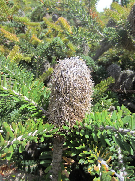
Dried pod of a banksia.
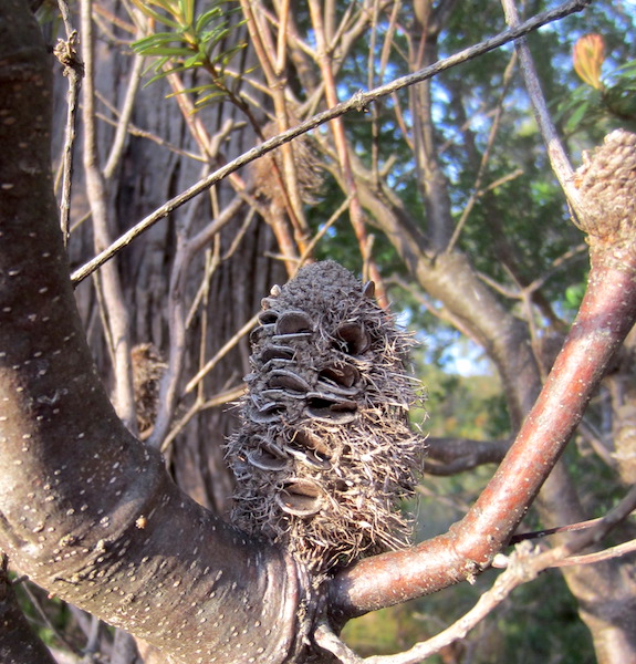
Fire has triggered the opening of the follicles and the release of seed from this banksia fruiting structure. These dried cones provide the basis for the appearance of the bad banksia men in May Gibbs’ Gumnut stories…hairy, knobbly and many-eyed creatures.
The banksia is named after Sir Joseph Banks (1743-1820) the eminent English botanist. Banks took part in Captain James Cook’s first great voyage (1768-1771) to Australia during which time hundreds of botanical specimens were collected.
The Ida Bay train left and we walked back along the track, dropped down onto the beach and made it back to base camp late afternoon. During the day we experienced what felt like seven winters and seven summers and each time we changed from winter gear to summer gear and back. At basecamp the wind was still blowing strongly, I estimated it was at times around 50kph with gusts to 65kph. The wind was whipping up sand around our tent and we couldn’t help but think of the desert Berbers of Morocco. Quite a number of people I know would have felt very uncomfortable in such conditions but when it is not as comfortable as one would like I always think of what my mother used to say, ‘count your blessings’. Our blessings were the absence of Delhi belly, toothache, the flu or a cold and it wasn’t raining.

A very sandy camp.
Sometimes, however, blessings are hard to come by. On one occasion in the 1970s when travelling with motorbike through Kenya I had few to count. Because the hostel in which we intended to stay was full of hashish-inebriated locals, Ian, my travelling companion, and I chose to sleep under a fly strung between two trees. Unfortunately I had the flu and lying on saturated ground in a wet sleeping bag, shaking, with water running under me, it was hard to think of any blessing that I could count. That night was one of those nights I have never forgotten.
The wind stopped suddenly in the evening. Why a gale that had been raging for almost twenty hours would stop with such abruptness intrigued me. To date, I have not been able to find out the reason. I guess one day it will come to me, in the meantime I will put it down to the vagaries of Tasmanian weather.
Taking advantage of the zero wind next morning we made a quick exit. Early morning conditions are usually calmer and we wanted to take any window of opportunity that might present itself. There was no mobile phone service and radio reception was erratic so we had to resort to reading the clouds and letting nature be our guide. Fortunately the morning was calm and we crossed the narrows and bay without mishap and by mid morning we were on the road south to Recherche Bay to continue following in the footsteps of French explorer Bruni d’ Entrecasteaux and botanist Jacques Labilladiere.

Breakfast back at calm Southport beach.

Beach dinner at Safe Haven campsite.

A peaceful landscape at Deep Hole jetty.
That’s the end of this post. We have had great joy reminiscing while writing this post. The next post deals with the experiences of the first French scientific expedition to arrive on Australian soil in 1791. It’s a remarkable story and I hope you stay with us. If you wish to make a comment please do so and if you want to be alerted each time we do a post click on FOLLOW and you will receive an email advising you of our latest adventure.

Hi guys,
Really enjoyed this post.
Tassie is such a beautiful part of Australia.
As usual looking forward to your next adventure.
Take Care xx
Hi Kevin and Sue
Yes Tassie is a beautiful place but it is under threat from mass tourism. Not the likes of us or you who are prepared to put on a pack and walk (or kayak). The Tasmanian government see the wilderness as a golden goose to be exploited. I am glad we did our exploration of the wilderness before the tourists arrived. But I suppose it (the tourism) is what is called progress in the corporate world.
Thanks for the comment. Fred and Bev