OUR JOURNEY TO TASMANIA — LAND of the ANTIPODEANS
WEST COAST WILDERNESS
Corinna and the Pieman River.

The Pieman River West Coast Tasmania
From Arthur River we pushed on south to Corinna on the Pieman River where we made camp in a tent-only camping area. Timber platforms were provided for tents. These platforms are beneficial because sometimes the sites are wet and a tent in water is not the best, especially if there is a hole in the tent floor.
Even though the camping area was tent-only designated we were able to squeeze our camper in. Our camper is only the size of a small double bed, not at all like the large caravans and motor homes on the roads these days. One caravan owner came into the site and the driver complained. ‘How do they expect us to fit in here and there is not even any electricity’. My reply was that we find it refreshing to go to places and not be surrounded by caravans. This is not a derogatory remark as we have friends with caravans, it’s the desire to be alone.

This is how caravans used to be, small and humble.

An old van restored and attached to a mean-looking go-anywhere 4WD truck

A big rig like this would not fit in the Corinna campsite.
The big rig in the above photograph would most probably be self-contained with shower, toilet and laundry. Our humble double bed size rig is parked in front of the big one.
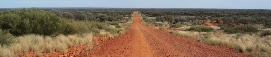
The drive from the Arthur River to the Pieman River was picturesque and a challenge as the road followed the natural contours of the land. There were many blind corners and crests and it required intense concentration, especially when there was the possibility of meeting a large log truck head on. At one point the road climbed what I estimated was a 25% gradient, most unusual for a road in Australia.

The road from Arthur River to the Corinna on the Pieman River.
The road was unsealed and passed through fire-ravaged coastal heathlands and severely burnt forest country. We stopped and gazed in wonder and tried to imagine the severity of the fires that swept over the land.
Fire ecologist Prof David Bowman, University of Tasmania, suggests the fires in Tasmania over the last few years are a sign of climate change. He states, ‘This is what climate change looks like, this is what scientists have been telling people, this is system collapse’. Warnings have been issued that there will be more lightning strikes in the future, which are the cause of the majority of wild fires worldwide.

The road heading through severely burnt country.

Scorched forest.
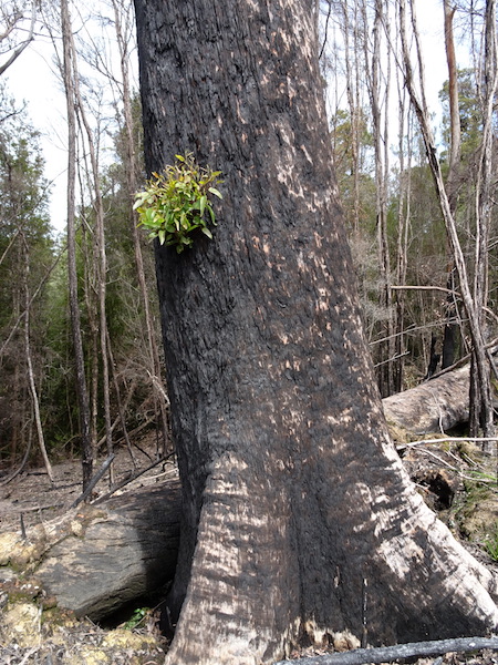
Burnt eucalyptus. The epicormic buds part way up the trunk signal the tree is still alive.
The oil from eucalyptus trees is highly flammable. Sometimes trees explode and these fragments can set the eucalyptus oil-rich atmosphere ablaze creating an intense fireball.
The first shower of rain after a fire brings volunteer plants to the fore and one Bev spotted was the white flag iris.

White flag iris (Diplarrena moraea), one of the first plants to surface after a fire.
The first time this plant was described was in 1792 by French botanist Jacques Labillardiere when exploring Southport Lagoon in southern Tasmania: ‘I discovered a very beautiful plant, which forms a new genus very distinct from any that has hitherto been described. It resembles the iris…’
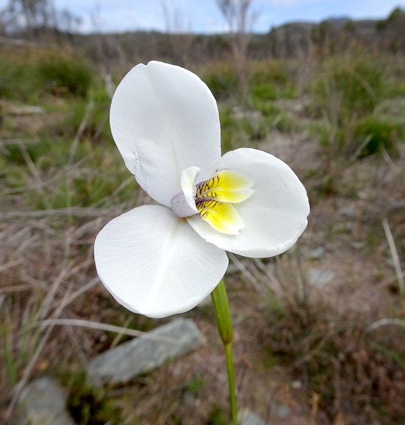
Close up of the native iris.
Burnt trees deemed likely to fall on the road after a fire are felled before the road is reopened.

A giant eucalypt that couldn’t be saved.
Our last visit to Corinna, the small hamlet on the Pieman River, was thirty years ago when we took our two boys canoeing to the mouth of the river. At the time there was only a small camping area hacked out of the rainforest and a rough shed to get out of the weather.

The rough shed in which we sheltered 30 years ago. It has changed little except for the addition of a solar panel on the roof.

On the Pieman with the boys in 1986.
Today there is a hotel with nineteen luxury cabins attached, a store and an official camping area. For us it has lost its charm, as have a lot of other places visited during our Encountering the Past travels over the past four years, however it is progress and one must not dwell on the desire for the ‘good old days’.

A peaceful Pieman River
There are no free camps in the vicinity of Corinna due to the steepness and density of the rainforest and we were forced to stay in the official area. Fees at the camping area are the most expensive we have encountered anywhere in the world, $40 for a tent site regardless of how many people there are in the party (very expensive for a lone traveller) and an extra $2 for a shower and if you want wood for a campfire the sign says you have to cough up an extra $10. One redeeming feature is the covered communal campfire and at night the topic of conversation around the fire was the cost of a pitch. It’s understandable as getting goods and services to such a remote location as Corinna costs but the extra $2 for a shower on top of the $40 was too much. Some of the travellers we talked to refused to take a shower on principle. Of course some might argue that if you want to save money stay at home but the extra dollars for a shower upset the campers we spoke with.

Our Corinna camp. Note the wooden platform with tent.
Corinna has many claims to fame, other than being an expensive place to camp. One is how the Pieman River acquired its name and another is that it is the home of the motor vessel Arcadia 2.
There is debate over whether the river was named after Thomas Kent or Alexander Pearce. In 1816 pastry cook, Thomas Kent, nicknamed the Pieman, was transported to Tasmania (Van Diemen’s Land) and after a long series of offences he was sent to Macquarie Harbour Penal Station, just south of the Pieman. He escaped and was later apprehended near the mouth of the river that is now referred to as the Pieman. Alexander Pearce was a convict transported to Macquarie Harbour, who escaped several times. In his escapades he killed and ate his companions to survive. Because of this repeated cannibalism he became known as ‘The Pieman’. Both men’s escapes took them through the rugged Pieman area.

Arcadia 2 on a tranquil Pieman River.
Arcadia 2 was built in 1939, it is built from Huon pine and was used as a leisure craft by its owner. In 1941 the boat was requisitioned by the Royal Australian Navy and in 1944 was sent to New Guinea to be used as a supply ship. Following the end of the war she served as a training vessel and after decommissioning was returned to Tasmania and used as a scallop boat. In 1970 she came to the Pieman and since then has been used to take tourists from Corinna to the mouth of the Pieman River, a distance of approximately eighteen kilometres.

The mouth of the Pieman River, looking west across the Indian Ocean.
The river for most parts is bound on both sides by rainforest, there are no steep banks except part way down to the mouth where there is a gorge known as Hell’s Gate.

Hell’s Gate on the Pieman.
In the 1960s an investigation was carried out with the aim of building a dam across Hell’s Gate. However the proposal was abandoned as the 43 metres of water and 120 metres of base sediments made the construction uneconomical. Following the unsuitability of the Hell’s Gate site the Reece Dam was built further upstream.
During the 1970/80s the Hydro-Electric Commission Tasmania built many dams with little consideration of the environment. Some people suggested that the Hydro-Electric Commission actually determined government policy. Of the dams proposed the most controversial was the Franklin River Dam but fortunately for the lovers of wild rivers it was never built and the river remains in its pristine condition. Bev and I were actively involved in saving the Franklin River, a fact we are proud of. Our concern at the time was that another piece of Australian wilderness was going to be lost forever and this would have been a travesty for future generations.
In 1972 the construction of a series of dams across the Serpentine and Huon Rivers caused much discussion between conservationists and the government of the day. The flooding of the valleys inundated a white quartzite beach and sand dunes of the original Lake Pedder. Up until the flooding only determined bushwalkers walked to the original Lake Pedder shores. Unfortunately we never had the pleasure of visiting the original lake as we didn’t start venturing into the wilderness until the 1980s.

Lake Pedder (circa 1968-1972) before the dams were built. The lake was formed about 10 000 years ago during the last ice age. Image credit: Stefan Karpiniec via Wikipedia.
Many Australians objected to the dams but they thought because the area had national park status (granted in 1955) it was secure from interference. However, that wasn’t the case as the national park status was revoked in 1967 allowing the dam to go ahead. The flooding of Lake Pedder was considered by many Australians to be an act of government vandalism.

The artificial Lake Pedder. The original lake is now under thirty metres of water.

Lake Pedder today, a large expanse of water.
Many of the people who objected to the flooding of Lake Pedder went on to form the first green political party in the world and at the moment the Greens have standing members of parliament in six of Australia’s seven states plus federal members as well.
An unfortunate fact relating to the flooding is that less than half the water is used for its original purpose and because of this studies have been carried out with the idea of draining the lake and rehabilitating the beach. If the artificial Lake Pedder is drained and the beach restored people would be lining up to see the original wonderful creation of nature.
The Pieman River mouth is a very remote place, however this does not mean there is no human habitation. There are fishermen’s shacks, many of which show how creative man can be when only junk materials are available.

Fishermen’s shacks at the mouth of the Pieman.

A 1986 image of the same shack as in the previous photo.
All over Tasmania there are shacks where, in years gone by, Tasmanians simply squatted and built on crown land without regulation or government interference. In latter years ownership has been formalised. Shacks these days can cost up to $200 000.

A bus converted to a shack. Image taken in 1986.
Shacks, no matter where they are, need three things and that is water, a toilet and somewhere to keep the beer cold. The following photographs show all three criteria.

Stepped 44s, not a drop of rainwater lost. Image from 1986

An innovative flush pit dunny, Central Highlands Tasmania.
In all the years of looking into the bush outhouse I have never found a loo flushing into a pit as in the above image. Roof run-off is stored in the 44 gallon drum on a stand at the back and a garden hose goes inside keeping the cistern full.

The beer fridge. Image from 1986.
Empty beer bottles, ‘dead marines’, in front of a flattened 44 gallon drum wall. Image from 1986.
The origin of the term ‘dead marines’ relating to empty bottles: In the 1700s hard drinking was carried out aboard ships and when William lV was Lord High Admiral he pointed to some empty bottles at an official dinner and ordered, ‘Take those dead marines away’. A senior officer who happened to be a marine suggest to the admiral that calling the empty bottles dead marines was derogatory. The admiral in a tactful edit said, ‘I call them marines because the good fellows have done their duty and are ready to do it again’.
There are a number of rainforest walks in the vicinity of Corinna. On one walk to the top of a nearby mountain we discovered a new fungi. It took about three hours to reach the top as it was a little precarious in light of the track being wet and slippery. In fact, it was so wet that freshwater crayfish had made burrows on the track.

Golden curtain crust (Stereum ostrea).

Close up view of the golden curtain crust.
Fungi do not possess chlorophyll therefore they do not need sunlight to grow.

Freshwater crayfish burrow. I’m not sure which species this is but I will endeavour to find out.
Few people get the opportunity to see a freshwater crayfish as they are mostly nocturnal and live in subterranean tunnels reaching down into the water table. If one runs short of drinking water when walking in the wilderness a short length of plastic tube can be inserted into the hole and the water sucked out.
There are two species of freshwater crayfish living in Tasmania, Engaeus spinicaudatus and E. granulatus. The names don’t mean much to me, or possibly 99% of the readers of this blog, but I couldn’t find a common name for them. The Engaeus species live in a variety of habitats from open water swamps to terrestrial burrows in rainforests.

Central North burrowing crayfish. Image credit: Photo by Niall Doran via theconversation.com web page.
The burrowing crayfish are a listed endangered species due to habitat destruction. Their survival is threatened by the clearance of native vegetation for agriculture, forestry, housing estates, drainage works for soil improvement, road works and polluted aquifers. Hard-hooved domestic animals such as horses and cows also destroy crayfish burrows when they stomp about feeding.
Because the freshwater crayfish is threatened, developers, road workers and forestry workers have to avoid destroying burrows. There have been instances where colonies have been relocated but it is a costly exercise, up to $300 per burrow. To relocate the crayfish it is not a simple matter of scooping up a colony and dropping it into a previously dug hole. Each crayfish has to be relocated one at a time otherwise, if done on mass, the aggravated animals set to and kill each other.
The information in the previous paragraphs relating to the burrowing freshwater crayfish was gleaned from theconversation.com web page. It is an excellent reference to hook onto if you are at all interested in matters pertaining to natural science. My Tasmanian friend Max, who is a retired water resources engineer and has been involved with the crayfish issue, also gave me an insight into the life of freshwater crayfish.
There is something very special about walking and camping in wet rainforest, although at times it can be a tad uncomfortable as everything is damp and it is almost impossible to light a fire. Bev is not a lover of rainforest camping but sometimes it has to be done, the following photograph shows what I mean.

Wet rainforest camp with our youngest son.
The camp above was in the New England NP in northern NSW. We attempted to have a fire but it was evident from the smoke and lack of flames we were not having much success.
At the end of the Pieman rainforest walk there was a sign detailing the exploits of gold miners in decades past. The miners of the 1800s would have been a hardy lot as living conditions would have been more than desperate. They would have lived in leaky calico tents or bark huts and lived off the land eating pademelons, possums and probably freshwater crayfish.
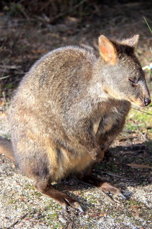
A sleepy Tasmanian pademelon. The rufous-bellied pademelon is the sole species found in Tasmania.
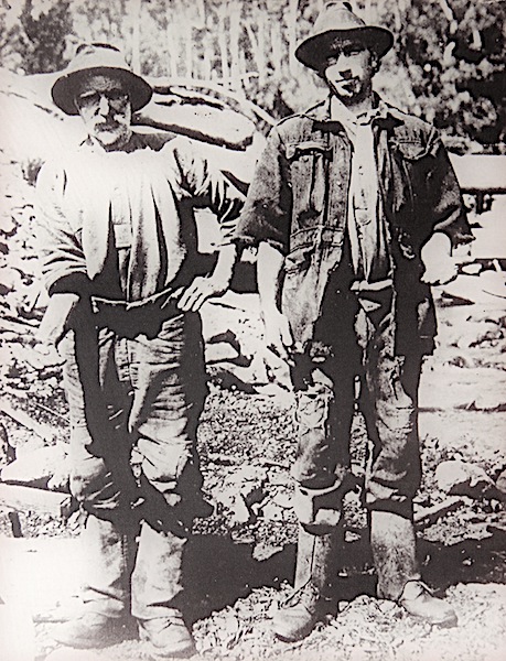
A couple of battling miners who worked in the Pieman River area.
The new pub at Corinna is not the first. There was one there during early mining days and the publican said of miners who frequented the pub ‘…to see the poor fellows coming in for provisions, all wet and cold, some scarcely a dry stitch upon them, and having to tear through this almost inaccessible scrub, you would say they deserve the gold’.

The car ferry across the Pieman.
LEAVING CORINNA
There are only two roads out of Corinna, north towards Arthur River but with a turn in the direction of Waratah or south, across the river by ferry and onto Zeehan and Queenstown. Along the way, there were a number of photographic opportunities. Following are a few images of interest.

The Tasmanian waratah, perhaps why the town of Waratah is so named.
There are five species of waratah (Telopeas) in Australia and the only difference I can see between the mainland species and the Tasmanian one is the latter has less inflorescences. Mainland waratahs are protected as their numbers are in decline. In Tasmania, harvesting of waratahs in the wild is still carried out.

There is a free camp at Waratah on the shores of the town water supply dam just a couple of kilometres out of town.

A Georgian swayback shingle roof shack providing shelter for cows.
The building above is an historical monument as it represents an era of Tasmanian history. It’s a shame some effort is not made to keep the cows out of the building, as they will ultimately knock it over. When I see an old building such as this I ponder the statement, ‘if only the walls could talk’.
The reference to Georgian: the Georgian period of architecture was very symmetrical around a centre line, for example, the central door with window either side.
Wooden shingles along with bark were used extensively in Australia for roofing. Thatch was not so common as native wildlife such as the possum decided thatch roofs were ideal places to set up home, and a possum in the roof can create havoc for those living below. The most commonly used tree for shingles was she oak, a name that early settlers gave to a particular species of casuarina. These shingles didn’t last as long as English oak shingles. One reference I came across inferred the name ‘she oak’ came because women were considered inferior. Using this name these days is considered sexist, the more politically correct name is river oak or casuarina.

A simple dwelling that was once someone’s pride and joy now surrounded by a felled eucalypt plantation.

Log trucks carting away plantation logs past the simple farm dwelling.
There was a time when protests were staged against clear felling and noted Australian singer songwriter John Williamson wrote and performed, as part of the protests, a song ‘Rip Rip Wood Chip’.
Rip rip wood chip / Turn it into paper / Throw it in the bin / No news today
Nightmare, dreaming /can’t you hear the screaming /
Chainsaw, eyesore, more decay.
The chorus of John Williamson song brings this post to an end. The next post will take you to the southeast of Tasmania to Southport Lagoon. Should you like to make a comment please feel free to do so and if you want to follow our travels in the Land of the Antipodeans and future Encountering the Past adventures click on FOLLOW and you will be alerted each time I do a posting.
